IMAGES TAKEN NEAR TO
Bernard Terrace, GLASGOW, G40 3BQ
Introduction
This page details the photographs taken nearby to Bernard Terrace, G40 3BQ by members of the Geograph project.
The Geograph project started in 2005 with the aim of publishing, organising and preserving representative images for every square kilometre of Great Britain, Ireland and the Isle of Man.

There are currently over 7.5m images from over14,400 individuals and you can help contribute to the project by visiting https://www.geograph.org.uk
Image Map
Images are licensed for reuse under creativecommons.org/licenses/by-sa/2.0
Notes
- Clicking on the map will re-center to the selected point.
- The higher the marker number, the further away the image location is from the centre of the postcode.
Image Listing (176 Images Found)
Images are licensed for reuse under creativecommons.org/licenses/by-sa/2.0
Image
Details
Distance
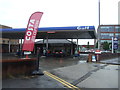
1
Bernard Terrace
Runs parallel with London Road.
Image: © Thomas Nugent
Taken: 14 Jul 2012
0.00 miles
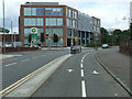
2
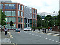
Eastgate on London Road
Built by the Dawn Group, this state-of-the-art 6,000-square-metre development cost £9.7m and is the new Headquarters of Glasgow Community Safety Services (GCSS) www.saferglasgow.com
Image: © Thomas Nugent
Taken: 14 Jul 2012
0.03 miles
3
Eastgate on London Road
Built by the Dawn Group, this state-of-the-art 6,000-square-metre development cost £9.7m and is the new Headquarters of Glasgow Community Safety Services (GCSS) www.saferglasgow.com
The cycling lanes are part of a new network which is springing up around the new Sir Chris Hoy Velodrome.
Image: © Thomas Nugent
Taken: 14 Jul 2012
0.03 miles
4
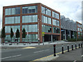
Eastgate on London Road
Built by the Dawn Group, this state-of-the-art 6,000-square-metre development cost £9.7m and is the new Headquarters of Glasgow Community Safety Services (GCSS) www.saferglasgow.com
Image: © Thomas Nugent
Taken: 14 Jul 2012
0.03 miles
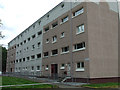
5
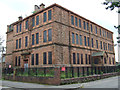
Former Queen Mary Street school
Viewed from Bernard Terrace, with Montgomery Street on the right.
Image: © Thomas Nugent
Taken: 14 Jul 2012
0.04 miles
6
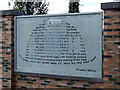
Frankie Miller Tribute
The security fence at Eastgate Image contains tributes to the history of Bridgeton and its people, including the singer and songwriter Frankie Miller http://www.frankiemiller.net/ .
The words form the shape of Miller's trademark bowler hat.
"I left my home
in Brigton town with all the
buildings falling down went to
seek my fortune went to seek my fame
all the folks I knew so well all the stories
fit to tell my ma said the boy child's got to
roam lord knows when I'll wend my way back
home well I wander here and I wander there I
wander almost everywhere got to find my baby
got to find my soul lord knows when I'll wend my
way back home though I'm not in trouble though
I'm not in pain each and every bar room get to look
the same I've been up all night just walking around
with all the places shutting down looking at the long
lost lonely souls lord knows when I'll wend my way back home
Frankie Miller"
Image: © Thomas Nugent
Taken: 7 Oct 2012
0.04 miles
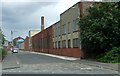
7
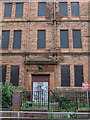
Former Queen Mary Street school
The Boys entrance on Bernard Terrace.
Image: © Thomas Nugent
Taken: 14 Jul 2012
0.04 miles
8
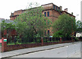
Former Queen Mary Street school
Now hidden behind trees since the school closed in 2009. This is the Bernard Terrace side of the building.
Image: © Thomas Nugent
Taken: 14 Jul 2012
0.05 miles