1
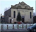
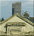
The restored Doulton Fountain, Glasgow Green with Templeton's Carpet Factory in the background
Image: © Patrick Lee
Taken: 1 Sep 2005
0.10 miles
2
Bellgrove railway station, looking WNW
Looking roughly WNW at Bellgrove railway station, where 320 317 is at platform 1 with the 18:27 service to Garscadden.
Image: © Andrew Reid
Taken: 5 Aug 2011
0.10 miles
3
Tureen Street Public School
Tureen Street School was designed by architect John Honeyman, and built in 1875. Born in Glasgow, Honeyman set up an architectural practice in the city in 1862, one of his first works being Lansdowne United Presbyterian Church on Great Western Road.
Other prominent Glasgow buildings with which he is associated include North Park House, the Ca' D'Oro Building, Trinity Congregational Church and numerous schools such as Rockvilla and Burnbank Primaries.
Image: © Colin Kinnear
Taken: 28 Feb 2023
0.10 miles
4
Barrowland Ballroom, Glasgow
This glittering neon landmark is situated in Glasgow's East End, however it looks like it could do with a bit of a clean-up.
Image: © GaryReggae
Taken: 25 Sep 2006
0.10 miles
5
St Luke's + St Andrew's
Church of Scotland, Gallowgate Parish Church on Bain Square.
A Category B Listed building http://data.historic-scotland.gov.uk/pls/htmldb/f?p=2200:15:0::::BUILDING:44053 .
Image: © Thomas Nugent
Taken: 30 Dec 2009
0.10 miles
6
Calton New Parish Church
A Category B Listed building http://data.historic-scotland.gov.uk/pls/htmldb/f?p=2200:15:0::::BUILDING:44053 overlooking Bain Street and The Barras.
Image: © Thomas Nugent
Taken: 17 May 2014
0.11 miles
7
New Calton parish Church
A Category B Listed building http://data.historic-scotland.gov.uk/pls/htmldb/f?p=2200:15:0::::BUILDING:44053 overlooking Bain Street and The Barras.
Image: © Thomas Nugent
Taken: 17 May 2014
0.11 miles
8
Saint Luke's
A former church on Bain Street which closed in 2012 and was converted to a music and events venue in 2015 http://www.stlukesglasgow.com/ . Category B Listed http://portal.historicenvironment.scot/designation/LB44053 .
See also
Image
Image: © Thomas Nugent
Taken: 19 Nov 2016
0.11 miles
9
St Luke's + St Andrew's Church
Church of Scotland, Gallowgate Parish Church on Bain Square. A Category B Listed building http://data.historic-scotland.gov.uk/pls/htmldb/f?p=2200:15:0::::BUILDING:44053 .
Viewed from the old clay pipe factory on Bain Street.
Image: © Thomas Nugent
Taken: 20 Sep 2014
0.12 miles
10
St Luke's + St Andrew's Church
Church of Scotland, Gallowgate Parish Church on Bain Square.
A Category B Listed building http://data.historic-scotland.gov.uk/pls/htmldb/f?p=2200:15:0::::BUILDING:44053 .
See also
Image
The "Gallowgate Twins" towerblocks can be seen in the distance
Image
Image: © Thomas Nugent
Taken: 20 Sep 2014
0.12 miles


