IMAGES TAKEN NEAR TO
Dornoch Street, GLASGOW, G40 2QT
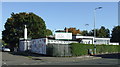
Introduction
This page details the photographs taken nearby to Dornoch Street, G40 2QT by members of the Geograph project.
The Geograph project started in 2005 with the aim of publishing, organising and preserving representative images for every square kilometre of Great Britain, Ireland and the Isle of Man.

There are currently over 7.5m images from over14,400 individuals and you can help contribute to the project by visiting https://www.geograph.org.uk
Image Map (Loading...)


Getting Data...Please wait
Leaflet Map data © OpenStreetMap
Images are licensed for reuse under creativecommons.org/licenses/by-sa/2.0
Notes
- Clicking on the map will re-center to the selected point.
- The higher the marker number, the further away the image location is from the centre of the postcode.
Image Listing (174 Images Found)
Images are licensed for reuse under creativecommons.org/licenses/by-sa/2.0
Image
Details
Distance
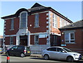
1
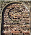
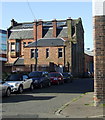
City of Glasgow College
The AD 1890 date stone on the Kerr Street side of the Dornoch Street campus of the college http://www.cityofglasgowcollege.ac.uk/ .
Image: © Thomas Nugent
Taken: 8 Oct 2012
0.00 miles
2
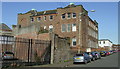
City of Glasgow College
The Dornoch Street campus of the college http://www.cityofglasgowcollege.ac.uk/ .
Image: © Thomas Nugent
Taken: 8 Oct 2012
0.01 miles
3
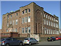
City of Glasgow College
The Dornoch Street campus of the college http://www.cityofglasgowcollege.ac.uk/ .
Image: © Thomas Nugent
Taken: 8 Oct 2012
0.01 miles
4
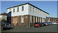
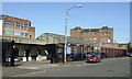
Kerr Street
An industrial building at the corner of Dornoch Street, which is on the left.
Image: © Thomas Nugent
Taken: 8 Oct 2012
0.02 miles
5
Dornoch Street
Viewed from Kerr Street.
Image: © Thomas Nugent
Taken: 8 Oct 2012
0.03 miles
6
Kerr Street
Industrial premises on the west side of the street.
Image: © Thomas Nugent
Taken: 8 Oct 2012
0.04 miles
7
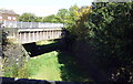
Former Glasgow City and District Railway line
Looking towards the Kerr Street bridge from the Crownpoint Street bridge. The line ran from High Street station to the former Bridgeton Cross (later renamed to Bridgeton Central) station which closed to passengers in 1979.
Image: © Thomas Nugent
Taken: 8 Oct 2012
0.06 miles
8
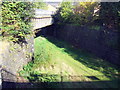
Former Glasgow City and District Railway line
Looking towards the Kerr Street bridge from the Crownpoint Street bridge. The line ran from High Street station to the former Bridgeton Cross (later renamed to Bridgeton Central) station which closed to passengers in 1979.
Image: © Thomas Nugent
Taken: 8 Oct 2012
0.06 miles
9
Mile End Out Of School Care
In what appears to be a former ARP centre at the corner of Crownpoint Road and Orr Street.
Image: © Thomas Nugent
Taken: 8 Oct 2012
0.06 miles
10
Bridgeton Family Learning Centre
On Orr Street. See also Image
Image: © Thomas Nugent
Taken: 8 Oct 2012
0.07 miles