IMAGES TAKEN NEAR TO
Millroad Drive, GLASGOW, G40 2DR
Introduction
This page details the photographs taken nearby to Millroad Drive, G40 2DR by members of the Geograph project.
The Geograph project started in 2005 with the aim of publishing, organising and preserving representative images for every square kilometre of Great Britain, Ireland and the Isle of Man.

There are currently over 7.5m images from over14,400 individuals and you can help contribute to the project by visiting https://www.geograph.org.uk
Image Map
Images are licensed for reuse under creativecommons.org/licenses/by-sa/2.0
Notes
- Clicking on the map will re-center to the selected point.
- The higher the marker number, the further away the image location is from the centre of the postcode.
Image Listing (120 Images Found)
Images are licensed for reuse under creativecommons.org/licenses/by-sa/2.0
Image
Details
Distance
1
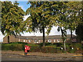
Houses off Millroad Street , G40
Shows the location of Image
Image: © Mike Quinn
Taken: 21 Oct 2010
0.04 miles
4
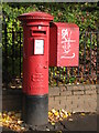
Edward VIII postbox, Millroad Street / Abercromby Street, G40
Image: © Mike Quinn
Taken: 21 Oct 2010
0.06 miles
5
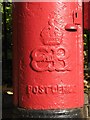
Edward VIII postbox, Millroad Street / Abercromby Street, G40 - royal cipher
See Image
Image: © Mike Quinn
Taken: 21 Oct 2010
0.06 miles
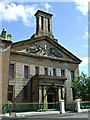
6
Saint Mary of the Assumption Pro-Cathedral, Abercromby Street, G40
Shows the location of Image
Image: © Mike Quinn
Taken: 21 Oct 2010
0.06 miles
7
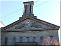
St Mary's RC Parish Church
On Abercromby Street at Forbes Street. See also Image
Image: © Thomas Nugent
Taken: 8 Oct 2012
0.06 miles
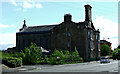
8
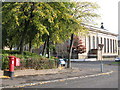
The School House
On Orr Street, viewed from Abercromby Street, with Abercromby Drive in the foreground.
Image: © Thomas Nugent
Taken: 26 May 2013
0.07 miles
9
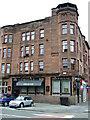
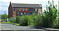
The Drover Bar
At the corner of Graham Square and Gallowgate. Once frequented by workers from the adjacent former Cattle & Meat Market. Click on this http://www.oldglasgowpubs.co.uk/drover.html for more information about the history of the pub.
The building dates from 1912 and is Category C Listed http://data.historic-scotland.gov.uk/pls/htmldb/f?p=2200:15:0::::BUILDING:33833 . The area under the cap on the corner of the roof was built as a clothes drying area Image
Image: © Thomas Nugent
Taken: 12 Jul 2014
0.07 miles
10
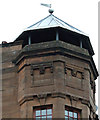
Cap house on Gallowgate
Built as a clothes drying area on a tenement at the corner of Graham Square Image A Category C Listed building http://data.historic-scotland.gov.uk/pls/htmldb/f?p=2200:15:0::::BUILDING:33833 .
Image: © Thomas Nugent
Taken: 12 Jul 2014
0.07 miles