IMAGES TAKEN NEAR TO
Abercromby Street, GLASGOW, G40 2DB
Introduction
This page details the photographs taken nearby to Abercromby Street, G40 2DB by members of the Geograph project.
The Geograph project started in 2005 with the aim of publishing, organising and preserving representative images for every square kilometre of Great Britain, Ireland and the Isle of Man.

There are currently over 7.5m images from over14,400 individuals and you can help contribute to the project by visiting https://www.geograph.org.uk
Image Map
Images are licensed for reuse under creativecommons.org/licenses/by-sa/2.0
Notes
- Clicking on the map will re-center to the selected point.
- The higher the marker number, the further away the image location is from the centre of the postcode.
Image Listing (280 Images Found)
Images are licensed for reuse under creativecommons.org/licenses/by-sa/2.0
Image
Details
Distance
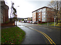
1
Craignestock mansions
In the Calton area of the east end of Glasgow,a few examples of tenements remain. Craignestock Mansions are one of these. Newer houses exist in parts of this area which are housing developments of the GEAR or post-GEAR eras. Many people who were cleared from the area when the tenement slums were demolished have now found their way back to live in the new houses.
Image: © Carol Walker
Taken: 25 Jan 2010
0.00 miles
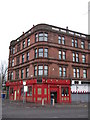
2
The Londoner public House
A traditional corner tenement bar http://www.oldglasgowpubs.co.uk/londoner.html on London Road at Abercromby Street (on the right).
Image: © Thomas Nugent
Taken: 19 Nov 2016
0.01 miles
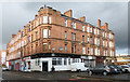
3
London Road
The Londoner pub at the corner of Abercromby Street.
Image: © Thomas Nugent
Taken: 26 May 2013
0.02 miles
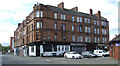
4
London Road, Glasgow
Abercromby Street is to the right of the tenement.
Image: © Thomas Nugent
Taken: 19 Nov 2016
0.02 miles
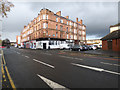
5
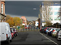
Abercromby Street
The black cloud was full of hail which descended on the area shortly after the photo was taken.
Image: © Thomas Nugent
Taken: 19 Nov 2016
0.03 miles
6
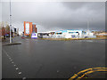
London Road at Abercromby Street
The re-aligned part of Abercromby Street is to the right of the white building with the blue trim.
Image: © Thomas Nugent
Taken: 19 Nov 2016
0.04 miles
7
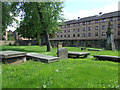
Calton Burial Ground
The burial ground is a Category B Listed building http://data.historic-scotland.gov.uk/pls/htmldb/f?p=2200:15:0::::BUILDING:33811 . Established 1786 by the Calton Incorporation of Weavers.
Image: © Thomas Nugent
Taken: 26 May 2013
0.04 miles
8
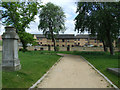
Calton Burial Ground
The burial ground is a Category B Listed building http://data.historic-scotland.gov.uk/pls/htmldb/f?p=2200:15:0::::BUILDING:33811 . Established 1786 by the Calton Incorporation of Weavers.
Image: © Thomas Nugent
Taken: 26 May 2013
0.06 miles
9
Silvergrove Street
Off London Road, near Kerr Street.
Image: © Thomas Nugent
Taken: 19 Nov 2016
0.06 miles
10
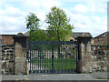
Calton Burial Ground
The burial ground is a Category B Listed building http://data.historic-scotland.gov.uk/pls/htmldb/f?p=2200:15:0::::BUILDING:33811 . Established 1786 by the Calton Incorporation of Weavers.
Image: © Thomas Nugent
Taken: 26 May 2013
0.06 miles