IMAGES TAKEN NEAR TO
London Road, GLASGOW, G40 1DZ
Introduction
This page details the photographs taken nearby to London Road, G40 1DZ by members of the Geograph project.
The Geograph project started in 2005 with the aim of publishing, organising and preserving representative images for every square kilometre of Great Britain, Ireland and the Isle of Man.

There are currently over 7.5m images from over14,400 individuals and you can help contribute to the project by visiting https://www.geograph.org.uk
Image Map
Images are licensed for reuse under creativecommons.org/licenses/by-sa/2.0
Notes
- Clicking on the map will re-center to the selected point.
- The higher the marker number, the further away the image location is from the centre of the postcode.
Image Listing (237 Images Found)
Images are licensed for reuse under creativecommons.org/licenses/by-sa/2.0
Image
Details
Distance
1
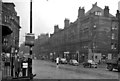
Bridgeton Central Station, entrance
View NW, towards High Street, Queen Street (Low Level) etc., and along London Road; ex-NBR North Clyde Suburban lines, terminus of branch from High Street. Station was called 'Bridgeton Cross' until 1954, plain 'Bridgeton' from 1965 until closed 5/11/79 when Argyle Line reopened. A grim scene?!
Image: © Ben Brooksbank
Taken: 6 Oct 1961
0.01 miles
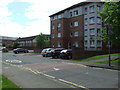
2
Silvergrove Street
Off London Road, near Kerr Street.
Image: © Thomas Nugent
Taken: 19 Nov 2016
0.03 miles
3
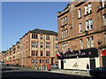
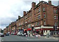
London Road
The Crimson Star bar is at the corner of Kerr Street.
Image: © Thomas Nugent
Taken: 8 Oct 2012
0.03 miles
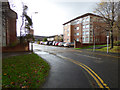
4
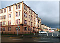
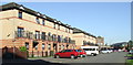
Silvergrove
Modern housing off London Road.
Image: © Thomas Nugent
Taken: 26 May 2013
0.03 miles
5
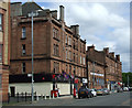
London Road
The Crimson Star pub at the corner of Kerr Street, with the former Bridgeton Cross railway station beyond (blue arched windows) Image
Image: © Thomas Nugent
Taken: 26 May 2013
0.03 miles
6
Kerr Street
Viewed from London Road, from where it is no longer directly accessible to traffic due to the bollards in the foreground.
Image: © Thomas Nugent
Taken: 19 Nov 2016
0.04 miles
7
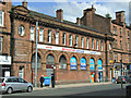
Former Bridgeton Cross railway station
A Category B Listed building http://data.historic-scotland.gov.uk/pls/htmldb/f?p=2200:15:0::::BUILDING:33853 on London Road, near the present day Bridgeton railway station.
Image: © Thomas Nugent
Taken: 26 May 2013
0.05 miles
8
Bridgeton Central railway station (site), Glasgow
Opened in 1892 as "Bridgeton Cross" by the North British Railway, this station was the terminus for the Glasgow & District trains from the north of the city. It was on a short branch line from High Street station. It was renamed "Bridgeton Central in 1954 and then became "Bridgeton" in 1965. It closed to passengers in 1979 (when it was replaced by Image) and completely in 1987.
View north east at the main building, which had become a convenience store when this image was taken. Behind it, the platform area has been redeveloped and is now housing.
Image: © Nigel Thompson
Taken: 12 Feb 2019
0.05 miles
9
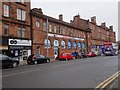
Kerr Street
Looking north from the London Road end.
Image: © Thomas Nugent
Taken: 8 Oct 2012
0.05 miles
10
London Road
Union Jacks and an Orange flag on display on the north side of London Road, near Bridgeton railway station.
The building with the lower roof line, behind the red car, is the former North British Railway Bridgeton Central Station http://www.glesga.ukpals.com/transport/brigtoncentral.htm .
Image: © Thomas Nugent
Taken: 14 Jul 2012
0.06 miles