IMAGES TAKEN NEAR TO
Perth Street, GLASGOW, G3 8UQ
Introduction
This page details the photographs taken nearby to Perth Street, G3 8UQ by members of the Geograph project.
The Geograph project started in 2005 with the aim of publishing, organising and preserving representative images for every square kilometre of Great Britain, Ireland and the Isle of Man.

There are currently over 7.5m images from over14,400 individuals and you can help contribute to the project by visiting https://www.geograph.org.uk
Image Map
Images are licensed for reuse under creativecommons.org/licenses/by-sa/2.0
Notes
- Clicking on the map will re-center to the selected point.
- The higher the marker number, the further away the image location is from the centre of the postcode.
Image Listing (360 Images Found)
Images are licensed for reuse under creativecommons.org/licenses/by-sa/2.0
Image
Details
Distance
1
St Patrick's Primary School, Perth Street, Glasgow
Image: © Leslie Barrie
Taken: 2 May 2014
0.01 miles
2
St Patrick's RC Primary School, Anderston
Viewed from a coach on the slip road from the Kingston Bridge to Bothwell Street.
Image: © Thomas Nugent
Taken: 23 Oct 2011
0.01 miles
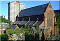
3
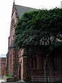
St Patrick's RC Church
A grand red sandstone building on North Street at William Street, by the busy M8 motorway. See also Image and Image
Image: © Thomas Nugent
Taken: 7 Sep 2009
0.01 miles
4
St Patrick's RC Church
Image: © Thomas Nugent
Taken: 7 Sep 2009
0.01 miles
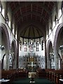
5
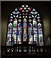
St Patrick's RC Church
Interior view of the stained glass window on the front facade of the church. See also Image and Image
Image: © Thomas Nugent
Taken: 7 Sep 2009
0.02 miles
6

Site of School Wynd
School Wynd ran north from Argyle Street, just to the east of Perth Street. The Two Fat Ladies restaurant is on the right. Part of St Patrick's RC School can be seen.
Image: © Thomas Nugent
Taken: 19 May 2013
0.02 miles
7
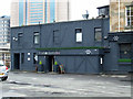
The Shandon Belles
At the Two Fat Ladies restaurant.
Image: © Thomas Nugent
Taken: 19 May 2013
0.04 miles
8
St Patrick's RC Church, Anderston
The large scale of this church is unfortunately best seen from the nearby M8 motorway sliproad to Bothwell Street. See the church interior here Image
Image: © Thomas Nugent
Taken: 1 May 2011
0.04 miles
9
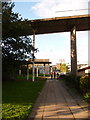
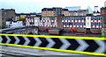
Glasgow: North Street pavement
This pavement runs alongside North Street, whose main carriageway is off to the right. The unusual sight in this scene is the railing of the footbridge, which alarmingly comes to an abrupt halt above us. All is revealed here: Image
Image: © Chris Downer
Taken: 25 Sep 2010
0.04 miles
10
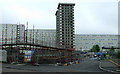
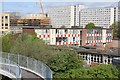
Construction site at Anderston
At Argyle Street. It's difficult to know if the towerblock on Shaftesbury Street is being demolished or refurbished. The long blocks of flats in the distance have an Eastern European appearance and are on St Vincent Terrace.
Image: © Thomas Nugent
Taken: 19 May 2013
0.04 miles