IMAGES TAKEN NEAR TO
Argyle Street, GLASGOW, G3 8RR
Introduction
This page details the photographs taken nearby to Argyle Street, G3 8RR by members of the Geograph project.
The Geograph project started in 2005 with the aim of publishing, organising and preserving representative images for every square kilometre of Great Britain, Ireland and the Isle of Man.

There are currently over 7.5m images from over14,400 individuals and you can help contribute to the project by visiting https://www.geograph.org.uk
Image Map
Images are licensed for reuse under creativecommons.org/licenses/by-sa/2.0
Notes
- Clicking on the map will re-center to the selected point.
- The higher the marker number, the further away the image location is from the centre of the postcode.
Image Listing (397 Images Found)
Images are licensed for reuse under creativecommons.org/licenses/by-sa/2.0
Image
Details
Distance
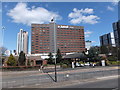
1
Glasgow Marriott Hotel
On Argyle Street.
Image: © Thomas Nugent
Taken: 20 May 2013
0.02 miles
3
Marriott Hotel, Argyle Street
At Anderston railway station.
Image: © Thomas Nugent
Taken: 31 Dec 2019
0.03 miles
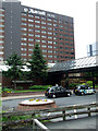
4
Anderston railway station
On a dark traffic island beneath the Kingston Bridge.
Image: © Thomas Nugent
Taken: 7 Sep 2009
0.03 miles
5
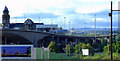
The Kingston Bridge
The north side of the bridge, viewed from the Clydeside Expressway.
Image: © Thomas Nugent
Taken: 18 Jul 2011
0.03 miles
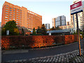
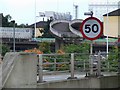
6

Anderston railway station
On a dark traffic island beneath the Kingston Bridge.
Image: © Thomas Nugent
Taken: 7 Sep 2009
0.04 miles
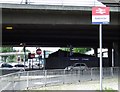
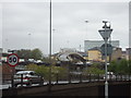
7
Bridge to nowhere
One of the many dead end bridges in the vicinity of the M8 Kingston Bridge.
2014 update - the bridge has been finished and opened as a pedestrian and cycle path across the M8 motorway Image
Image: © Thomas Nugent
Taken: 5 Oct 2008
0.04 miles
8
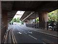
Newton Street, Glasgow
In the middle of junction 19 of the M8, Newton Street takes local traffic towards Argyle Street http://www.geograph.org.uk/photo/6201093 . Above are two separate slipways merging into the westbound M8 from Newton Street and Waterloo Street, respectively. Crossing above those is Anderston Bridge, taking a foot and cycle path across the motorway from central Glasgow (right) to Anderston (left).
Image: © Rudi Winter
Taken: 26 Jun 2019
0.04 miles
9
Bridge to nowhere, Anderston, Glasgow
Image: © Stacey Harris
Taken: 25 Apr 2012
0.05 miles
10

Anderston Footbridge (former bridge to nowhere)
This bridge was built when the M8 motorway north of the Kingston Bridge was built in the early 1970s. Until 2013 it was known as one of the "bridges to nowhere" (some pedestrian, some road) in this area which were never completed http://en.wikipedia.org/wiki/M8_Bridge_to_Nowhere .
This one was completed by Sustrans in July 2013, under their Connect2 scheme. It now provides a safe crossing of the M8 motorway from the city centre to the West End, linking up with cycle friendly routes at both sides.
See also Image & Image
Image: © Thomas Nugent
Taken: 20 Oct 2014
0.05 miles