IMAGES TAKEN NEAR TO
Lumsden Street, GLASGOW, G3 8RG
Introduction
This page details the photographs taken nearby to Lumsden Street, G3 8RG by members of the Geograph project.
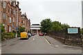
The Geograph project started in 2005 with the aim of publishing, organising and preserving representative images for every square kilometre of Great Britain, Ireland and the Isle of Man.

There are currently over 7.5m images from over14,400 individuals and you can help contribute to the project by visiting https://www.geograph.org.uk
Image Map
Images are licensed for reuse under creativecommons.org/licenses/by-sa/2.0
Notes
- Clicking on the map will re-center to the selected point.
- The higher the marker number, the further away the image location is from the centre of the postcode.
Image Listing (519 Images Found)
Images are licensed for reuse under creativecommons.org/licenses/by-sa/2.0
Image
Details
Distance
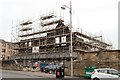
1
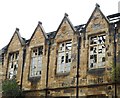
Former Overnewton School
Some of the glass still remains in the windows of the Category B listed school [http://portal.historicenvironment.scot/designation/LB33084] destroyed by a major fire in 2013.
The school closed in 1993, but became the Steiner School in 1994.
There may be plans to restore the building and convert it into residential accommodation.
Image: © Richard Sutcliffe
Taken: 16 Aug 2018
0.04 miles
2
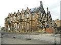
Former Overnewton School
Category B listed school [http://portal.historicenvironment.scot/designation/LB33084]. The school closed in 1993, but became the Steiner School in 1994. A major fire destroyed the building in 2013, leaving it as an empty shell. There may be plans to restore the building and convert it into residential accommodation.
Image: © Richard Sutcliffe
Taken: 16 Aug 2018
0.04 miles
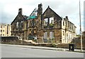
3
Former Overnewton School
Category B listed school [http://portal.historicenvironment.scot/designation/LB33084]. The school closed in 1993, but became the Steiner School in 1994. A major fire destroyed the building in 2013, leaving it as an empty shell. There may be plans to restore the building and convert it into residential accommodation. The building is surrounded by barriers due to its unsafe condition.
Image: © Richard Sutcliffe
Taken: 16 Aug 2018
0.04 miles
4
Dr Thirsty's Alehouse, Yorkhill, Glasgow
Bizarrely-named pub outside Yorkhill Hospital.
Image: © Mike Pennington
Taken: 3 Jan 2009
0.04 miles
5
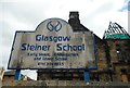
Sign for former Steiner School
The former Category B listed Overnewton School became the Steiner School in 1994. A major fire destroyed the building in 2013, leaving it as an empty shell.
Image: © Richard Sutcliffe
Taken: 16 Aug 2018
0.05 miles
7
Former Overnewton School
Category B listed school [http://portal.historicenvironment.scot/designation/LB33084]. The school closed in 1993, but became the Steiner School in 1994. A major fire destroyed the building in 2013, leaving it as an empty shell. There may be plans to restore the building and convert it into residential accommodation.
Image: © Richard Sutcliffe
Taken: 16 Aug 2018
0.05 miles
8
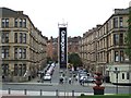
Glasgow: Scotland with style
Promotional banner at the junction of Argyle Street and Regent Moray Street. Viewed from Kelvingrove Museum & Art Gallery.
Image: © Thomas Nugent
Taken: 2 Sep 2007
0.05 miles
9
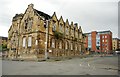
Entrance, Royal Hospital for Sick Children
Image: © Mark Anderson
Taken: 26 Jun 2019
0.07 miles
10

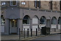
1349-1359 Argyle Street
Sandstone tenements on Argyle Street with businesses on the ground floor: 'Dining In - with Mother India'; 'Albany Antiques'; 'Mother India's Cafe; and 'The Little Cafe'.
Image: © Richard Sutcliffe
Taken: 13 Dec 2018
0.07 miles