IMAGES TAKEN NEAR TO
Ferry Road, GLASGOW, G3 8QR
Introduction
This page details the photographs taken nearby to Ferry Road, G3 8QR by members of the Geograph project.
The Geograph project started in 2005 with the aim of publishing, organising and preserving representative images for every square kilometre of Great Britain, Ireland and the Isle of Man.

There are currently over 7.5m images from over14,400 individuals and you can help contribute to the project by visiting https://www.geograph.org.uk
Image Map
Images are licensed for reuse under creativecommons.org/licenses/by-sa/2.0
Notes
- Clicking on the map will re-center to the selected point.
- The higher the marker number, the further away the image location is from the centre of the postcode.
Image Listing (412 Images Found)
Images are licensed for reuse under creativecommons.org/licenses/by-sa/2.0
Image
Details
Distance
1
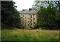
Back of tenements, Ferry Road
Seen from Yorkhill Park.
Image: © Richard Sutcliffe
Taken: 16 Aug 2018
0.01 miles
2
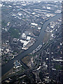
The River Clyde in Glasgow from the air
The River Kelvin can be seen joining in the lower left corner, with Riverside Museum on its left bank. West of Scotland cricket Ground at Partick can be seen on the right, The Govan shipyard and the Queen Elizabeth Hospital at Govan can also be seen. The King George V dock and Ikea at Braehead can be seen in the top right corner.
Image: © Thomas Nugent
Taken: 15 Apr 2019
0.02 miles
4
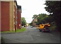
Centurion Way
Looking along the no through road.
Image: © DS Pugh
Taken: 6 Apr 2019
0.03 miles
5
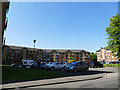
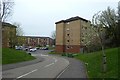
Housing development, Ferry Road
Built on the site of a former boiler works.
Image: © Stephen Craven
Taken: 26 Jun 2019
0.04 miles
6
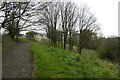
Path in Yorkhill Park
Leading through to Centurion Way.
Image: © DS Pugh
Taken: 6 Apr 2019
0.04 miles
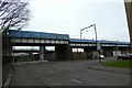
8
Railway Bridge, Ferry Road
This part of the road is no longer open to vehicles.
Image: © Mark Anderson
Taken: 26 Jun 2019
0.06 miles
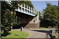
9
![Glasgow bridges [4]](https://s1.geograph.org.uk/geophotos/06/25/47/6254705_6a74c788_120x120.jpg)
Glasgow bridges [4]
This bridge carried the railway over Ferry Road which is now truncated at this point. Beyond can be seen part of the ramps carrying traffic from Castlebank Street down onto the Clydeside Expressway. For a view from the other side of the bridge see Image
Image: © Michael Dibb
Taken: 26 Jun 2019
0.06 miles
10
![Glasgow bridges [5]](https://s3.geograph.org.uk/geophotos/06/25/47/6254711_ae8e8258_120x120.jpg)
Glasgow bridges [5]
This bridge carried the railway over Ferry Road which is now truncated at this point. For a view of the other side of the bridge see Image
Image: © Michael Dibb
Taken: 26 Jun 2019
0.06 miles