IMAGES TAKEN NEAR TO
Old Dumbarton Road, GLASGOW, G3 8QB
Introduction
This page details the photographs taken nearby to Old Dumbarton Road, G3 8QB by members of the Geograph project.
The Geograph project started in 2005 with the aim of publishing, organising and preserving representative images for every square kilometre of Great Britain, Ireland and the Isle of Man.

There are currently over 7.5m images from over14,400 individuals and you can help contribute to the project by visiting https://www.geograph.org.uk
Image Map
Images are licensed for reuse under creativecommons.org/licenses/by-sa/2.0
Notes
- Clicking on the map will re-center to the selected point.
- The higher the marker number, the further away the image location is from the centre of the postcode.
Image Listing (485 Images Found)
Images are licensed for reuse under creativecommons.org/licenses/by-sa/2.0
Image
Details
Distance
1
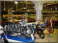
Inside the Museum of Transport
Inside the Museum of Transport, Glasgow.
Image: © Dannie Calder
Taken: 23 May 2008
0.01 miles
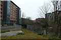
2
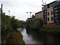
Construction work beside the Kelvin
Building work under way on the north bank of the River Kelvin.
Image: © Richard Sutcliffe
Taken: 2 Jul 2015
0.01 miles
3
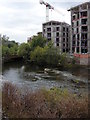
Construction work beside the Kelvin
Construction work continuing on new buildings beside the River Kelvin.
The water level in the Kelvin is low, and some rocks are showing above the surface.
Image: © Richard Sutcliffe
Taken: 9 Sep 2015
0.01 miles
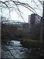
4
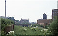
Former railway bridge over the River Kelvin
The bridge was built for the Lanarkshire and Dunbartonshire Railway in about 1896 https://canmore.org.uk/site/197365/glasgow-old-dumbarton-road-railway-bridge. On the right is the end of Partick Sewage Pumping Station and the former Scotstoun Mills. Beyond the bridge are the Category B listed former Bishop Mills http://portal.historicenvironment.scot/designation/LB33096. The building has scaffolding in place, as it was being converted to residential use. The chimney on the left is for the Queen Mother's Maternity Hospital. The area beside the river was the site of the Regent Flour Mills. These were demolished in 1978. Nature had taken over since then and many plants of giant hogweed had established themselves. Not long after this photograph was taken, the ground was redeveloped as a car park for the Kelvin Hall (just out of view on the left).
Scanned from an Ektachrome 64 colour reversal (slide) film.
Image: © Richard Sutcliffe
Taken: Unknown
0.01 miles
5
Old railway bridge
The remains of an old crossing of the River Kelvin. For a historic image in the other direction see https://canmore.org.uk/collection/796383
Image: © DS Pugh
Taken: 6 Apr 2019
0.01 miles
6
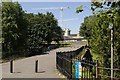
Snow Bridge, Glasgow
The design of this bridge allowed snow to be brought here and pushed into the river Kelvin through gates on the left.
Image: © Mark Anderson
Taken: 26 Jun 2019
0.01 miles
7
![Glasgow bridges [3]](https://s0.geograph.org.uk/geophotos/06/25/46/6254696_61497851_120x120.jpg)
Glasgow bridges [3]
Seen from Old Dumbarton Road, this rusting bridge carries a railway line over the River Kelvin.
Image: © Michael Dibb
Taken: 26 Jun 2019
0.02 miles
8
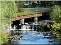
Old railway bridge over the River Kelvin
The bridge, built about 1896, carried the Lanarkshire and Dumbartonshire Railway over the River Kelvin [https://canmore.org.uk/site/197365/glasgow-old-dumbarton-road-railway-bridge]. To the left was Partick Central Station, while to the right was the Yorkhill tunnel. The bridge crosses the river at the point where there is a natural fall, which in the 19th century also acted as a weir for the adjacent mills.
Image: © Richard Sutcliffe
Taken: 27 Apr 2019
0.02 miles
10
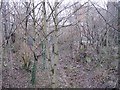
Disused railway
The Lanarkshire and Dunbartonshire Railway between crossing the Kelvin and entering a tunnel under Yorkhill Hospital.
Image: © Richard Webb
Taken: 2 Dec 2007
0.03 miles