IMAGES TAKEN NEAR TO
Kelvinhaugh Street, GLASGOW, G3 8PB
Introduction
This page details the photographs taken nearby to Kelvinhaugh Street, G3 8PB by members of the Geograph project.
The Geograph project started in 2005 with the aim of publishing, organising and preserving representative images for every square kilometre of Great Britain, Ireland and the Isle of Man.

There are currently over 7.5m images from over14,400 individuals and you can help contribute to the project by visiting https://www.geograph.org.uk
Image Map
Images are licensed for reuse under creativecommons.org/licenses/by-sa/2.0
Notes
- Clicking on the map will re-center to the selected point.
- The higher the marker number, the further away the image location is from the centre of the postcode.
Image Listing (301 Images Found)
Images are licensed for reuse under creativecommons.org/licenses/by-sa/2.0
Image
Details
Distance
1
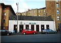
The 78
Bar on Kelvinhaugh Street.
Image: © Richard Sutcliffe
Taken: 13 Dec 2018
0.05 miles
2
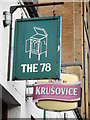
Sign for The 78
The bar is on Kelvinhaugh Street [https://www.geograph.org.uk/photo/6000567].
Image: © Richard Sutcliffe
Taken: 13 Dec 2018
0.05 miles
3
The oldest tree on Argyle Street
This ash tree is also the tallest tree on Argyle Street. In fact it is one of very few trees anywhere on the street.
Image: © Richard Sutcliffe
Taken: 13 Dec 2018
0.05 miles
4

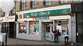
Sandyford Post Office
Featuring Stampbucks Coffee Bar.
Image: © Richard Sutcliffe
Taken: 13 Dec 2018
0.05 miles
6
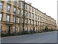
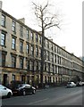
Victorian terrace on Argyle Street
A long terrace of tenements.
Image: © M J Richardson
Taken: 10 Apr 2010
0.06 miles
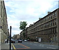
7

Tenement on Argyle Street
Dating from about 1845, this section of Argyle Street was originally called Franklin Terrace. The whole row of tenements are Category B listed [http://portal.historicenvironment.scot/designation/LB32946].
Image: © Richard Sutcliffe
Taken: 13 Dec 2018
0.06 miles
8
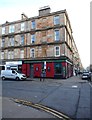
The Park Bar
At the corner of Argyle Street and Gray Street.
Image: © Richard Sutcliffe
Taken: 13 Dec 2018
0.06 miles
9
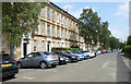
St Vincent Crescent
Looking east from the west end of the Category A Listed terrace http://portal.historicenvironment.scot/designation/LB33129 .
Image: © Thomas Nugent
Taken: 13 Jul 2018
0.06 miles
10
Argyle Street
The west end of the street, viewed from the Radnor Street junction.
Image: © Thomas Nugent
Taken: 12 Jul 2008
0.06 miles