IMAGES TAKEN NEAR TO
St. Vincent Street, GLASGOW, G3 8NR
Introduction
This page details the photographs taken nearby to St. Vincent Street, G3 8NR by members of the Geograph project.
The Geograph project started in 2005 with the aim of publishing, organising and preserving representative images for every square kilometre of Great Britain, Ireland and the Isle of Man.

There are currently over 7.5m images from over14,400 individuals and you can help contribute to the project by visiting https://www.geograph.org.uk
Image Map
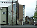
Images are licensed for reuse under creativecommons.org/licenses/by-sa/2.0
Notes
- Clicking on the map will re-center to the selected point.
- The higher the marker number, the further away the image location is from the centre of the postcode.
Image Listing (215 Images Found)
Images are licensed for reuse under creativecommons.org/licenses/by-sa/2.0
Image
Details
Distance
1
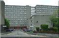
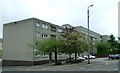
Houldsworth Street
Dominated by the St Vincent Terrace apartment blocks.
Image: © Thomas Nugent
Taken: 19 May 2013
0.04 miles
2
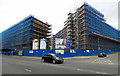
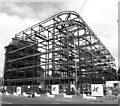
Building site on Argyle Street
At the junction with St Vincent Street (left) and Elliot Street (right). The line of Argyle Street continues between the new buildings under construction, so it will be interesting to see the finished article.
Image: © Thomas Nugent
Taken: 2 Jul 2017
0.05 miles
3
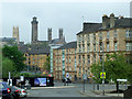
Elliot Street
The towers are at the former Trinity College Image and the former Park Church tower (leftmost), of which only the tower survives Image
Image: © Thomas Nugent
Taken: 19 May 2013
0.05 miles
4
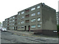
Houldsworth Street
To the left and to the right of the building.
Image: © Thomas Nugent
Taken: 19 May 2013
0.05 miles
5
Construction at the junction of Argyle Street and Breadalbane Street, Glasgow
Image: © habiloid
Taken: 29 Jul 2021
0.06 miles
6
Houldsworth Street
At Elliot Street, which is to the left.
Image: © Thomas Nugent
Taken: 19 May 2013
0.06 miles
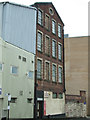
7
TA Parachute Regiment on Houldsworth Street
Territorial Army Reserve centre at the corner of Port Street.
Image: © Thomas Nugent
Taken: 19 May 2013
0.07 miles
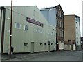
8
Former Vulcan Works on Houldsworth Street
A nineteenth century industrial building c.1877, built originally for P&R Fleming, ironmongery manufacturers, later occupied by J&A McFarlane who made household mangles (also known as wringers). It is currently occupied by MacCallum's of Troon, sea food merchants.
Image: © Thomas Nugent
Taken: 19 May 2013
0.07 miles
9
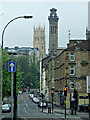
Elderslie Street
The towers are at the former Trinity College (on the right) Image and the former Park Church tower, of which only the tower survives Image
Image: © Thomas Nugent
Taken: 19 May 2013
0.07 miles
10
Houldsworth Street
The first building on the left is occupied by the Territorial Army Parachute Reserve.
Image: © Thomas Nugent
Taken: 19 May 2013
0.07 miles