IMAGES TAKEN NEAR TO
St. Vincent Crescent, GLASGOW, G3 8LH
Introduction
This page details the photographs taken nearby to St. Vincent Crescent, G3 8LH by members of the Geograph project.
The Geograph project started in 2005 with the aim of publishing, organising and preserving representative images for every square kilometre of Great Britain, Ireland and the Isle of Man.

There are currently over 7.5m images from over14,400 individuals and you can help contribute to the project by visiting https://www.geograph.org.uk
Image Map
Images are licensed for reuse under creativecommons.org/licenses/by-sa/2.0
Notes
- Clicking on the map will re-center to the selected point.
- The higher the marker number, the further away the image location is from the centre of the postcode.
Image Listing (356 Images Found)
Images are licensed for reuse under creativecommons.org/licenses/by-sa/2.0
Image
Details
Distance
1
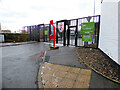
SP Energy depot, Finnieston
The main gate on St Vincent Crescent.
Image: © Thomas Nugent
Taken: 5 Jan 2021
0.01 miles
2
St Vincent Crescent
Between Corunna Street and Minerva Street.
Image: © Thomas Nugent
Taken: 24 Aug 2014
0.02 miles
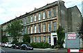
3
Tenements, St Vincent Crescent
Category A listed tenements [http://portal.historicenvironment.scot/designation/LB33128] dating from about 1855, by Alexander Kirkland.
Image: © Richard Sutcliffe
Taken: 17 Apr 2019
0.02 miles
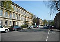
4

The eastern end of St Vincent Crescent
From its junction with Corunna Street. A fine Victorian Crescent built in the 1850s and designed by Alexander Kirkland.
Image: © M J Richardson
Taken: 10 Apr 2010
0.02 miles
5
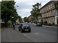
St Vincent Crescent
From the corner of Minerva Street.
Image: © Richard Sutcliffe
Taken: 16 Jun 2015
0.02 miles
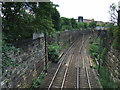
6
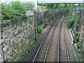
Railway line at St Vincent Crescent
Looking along the North Clyde Line towards Partick. The disused Glasgow Central Railway line runs under this line just beyond the nearest pair of catenary posts.
See also Image
The overhead bridge carries pipes and cables and is a fairly recent addition. See the same scene without this bridge in 2008 Image
Image: © Thomas Nugent
Taken: 24 Aug 2014
0.02 miles
7
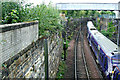
Railway line at St Vincent Crescent
Looking along the North Clyde Line towards Partick. The disused Glasgow Central Railway line runs under this line just beyond the nearest pair of catenary posts.
The train is an Edinburgh bound six car Scotrail Class 334.
See also Image
The overhead bridge carries pipes and cables and is a fairly recent addition. See the same scene without this bridge in 2008 Image
Image: © Thomas Nugent
Taken: 24 Aug 2014
0.02 miles
8
SP Energy depot, Finnieston
The SP Energy depot on St Vincent Crescent.
Image: © Thomas Nugent
Taken: 5 Jan 2021
0.02 miles
9
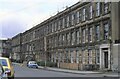
24-30 St Vincent Crescent
A terrace of properties dating from about 1855 and all Category A listed http://portal.historicenvironment.scot/designation/LB33128. At the time of the photograph many of the properties were needing attention. Number 27 has large wooden supports, due to subsidence. Although not obvious from above, an old railway tunnel runs underneath! Two years later a major conservation project led to all the properties being stone cleaned and renovated.
Scanned from an AGFA colour transparency.
Image: © Richard Sutcliffe
Taken: Unknown
0.02 miles
10
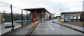
Railway tracks
Looking towards Partick station from the bridge at St Vincent Crescent. The disused Glasgow Central line crosses underneath these tracks in the foreground
Image: © Thomas Nugent
Taken: 12 Jul 2008
0.04 miles