IMAGES TAKEN NEAR TO
Elliot Street, GLASGOW, G3 8EX
Introduction
This page details the photographs taken nearby to Elliot Street, G3 8EX by members of the Geograph project.
The Geograph project started in 2005 with the aim of publishing, organising and preserving representative images for every square kilometre of Great Britain, Ireland and the Isle of Man.

There are currently over 7.5m images from over14,400 individuals and you can help contribute to the project by visiting https://www.geograph.org.uk
Image Map
Images are licensed for reuse under creativecommons.org/licenses/by-sa/2.0
Notes
- Clicking on the map will re-center to the selected point.
- The higher the marker number, the further away the image location is from the centre of the postcode.
Image Listing (374 Images Found)
Images are licensed for reuse under creativecommons.org/licenses/by-sa/2.0
Image
Details
Distance


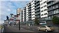
3
Lancefield Quay
At the junction with Elliot Street. The Finnieston Crane can be seen in the distance.
Image: © Thomas Nugent
Taken: 16 Apr 2012
0.04 miles
4

Betty's Bar and Lounge 1982.
Near to the docks.
Image: © Hugh Close
Taken: 1 Dec 1982
0.04 miles

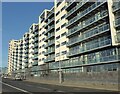
6

Apartment block at Lancefield Quay
Viewed from the Clyde Walkway.
Image: © Thomas Nugent
Taken: 24 Aug 2014
0.04 miles
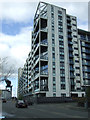
7

Lancefield Quay
Looking towards the Finnieston Crane.
See the same view, taken slightly further east, in 1982 Image
Image: © Thomas Nugent
Taken: 16 Apr 2012
0.05 miles
8
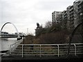
Wild quay
A fenced off area now growing wild.
Image: © Richard Webb
Taken: 2 Dec 2007
0.06 miles