IMAGES TAKEN NEAR TO
St. Georges Road, GLASGOW, G3 6JE
Introduction
This page details the photographs taken nearby to St. Georges Road, G3 6JE by members of the Geograph project.
The Geograph project started in 2005 with the aim of publishing, organising and preserving representative images for every square kilometre of Great Britain, Ireland and the Isle of Man.

There are currently over 7.5m images from over14,400 individuals and you can help contribute to the project by visiting https://www.geograph.org.uk
Image Map
Images are licensed for reuse under creativecommons.org/licenses/by-sa/2.0
Notes
- Clicking on the map will re-center to the selected point.
- The higher the marker number, the further away the image location is from the centre of the postcode.
Image Listing (267 Images Found)
Images are licensed for reuse under creativecommons.org/licenses/by-sa/2.0
Image
Details
Distance
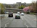
1
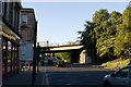
A804 St George's Road
Looking towards the Great Western Road bridge.
Image: © Mark Anderson
Taken: 26 Jun 2019
0.01 miles
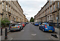
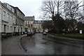
3
St George's Road
West Princes Street is to the right.
Image: © Thomas Nugent
Taken: 13 Feb 2009
0.03 miles
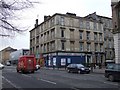
4
West Princes Street
At St George's Road, which is to the left.
Image: © Thomas Nugent
Taken: 13 Feb 2009
0.04 miles
6
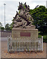
St. George and the Dragon (and the pigeons), St. George's Cross, Glasgow
Image: © habiloid
Taken: 30 Jul 2021
0.06 miles
9
Queen's Crescent
Looking towards the junction with West Prince's Street.
Image: © DS Pugh
Taken: 6 Apr 2019
0.06 miles
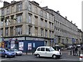
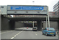
10
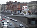
St George's Road
The East bound (actually north bound at this point) M8 is in the foreground.
Image: © Thomas Nugent
Taken: 13 Feb 2009
0.06 miles