IMAGES TAKEN NEAR TO
Balcurvie Road, GLASGOW, G34 9QH
Introduction
This page details the photographs taken nearby to Balcurvie Road, G34 9QH by members of the Geograph project.
The Geograph project started in 2005 with the aim of publishing, organising and preserving representative images for every square kilometre of Great Britain, Ireland and the Isle of Man.

There are currently over 7.5m images from over14,400 individuals and you can help contribute to the project by visiting https://www.geograph.org.uk
Image Map
Images are licensed for reuse under creativecommons.org/licenses/by-sa/2.0
Notes
- Clicking on the map will re-center to the selected point.
- The higher the marker number, the further away the image location is from the centre of the postcode.
Image Listing (13 Images Found)
Images are licensed for reuse under creativecommons.org/licenses/by-sa/2.0
Image
Details
Distance
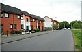
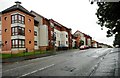
1
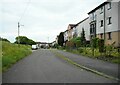
Balcurvie Road
Residential street.
Image: © Richard Sutcliffe
Taken: 1 Jun 2023
0.01 miles
2
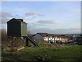
Dovecot at Provanhall
Looking down Balcurvie Road
Image: © Chris Upson
Taken: 17 Feb 2006
0.05 miles
3
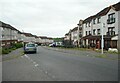
Conisborough Road
From the junction with Balcurvie Road.
Image: © Richard Sutcliffe
Taken: 1 Jun 2023
0.08 miles
4
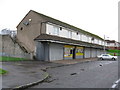
Row of Shops, Conisborough Road, Garthamlock
Only the licensed grocer now open for business.
Image: © G Laird
Taken: 29 Oct 2011
0.15 miles
5
Conisborough Road
Looking towards Auchinlea Road.
Image: © Richard Sutcliffe
Taken: 1 Jun 2023
0.16 miles
6
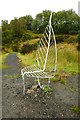
Leaf seat
An unusual seat at the Forestry Commission Scotland's Todds Well.
Image: © Richard Sutcliffe
Taken: 12 Aug 2018
0.17 miles
7
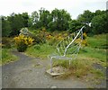
Leaf seat
This ornamental seat has got a new concrete base and has been bent backwards since photographed in 2018 Image Or has it just wilted?
Image: © Richard Sutcliffe
Taken: 1 Jun 2023
0.17 miles
8
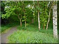
Path through the trees
The path leads through a small clump of woodland to Auchinlea Road.
Image: © Richard Sutcliffe
Taken: 1 Jun 2023
0.18 miles
10
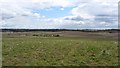
Fields off Gartloch Road
Gartloch Road was closed for water mains work, so I did a Parker and took to the fields. The foreground land was not in arable use or stockproofed so I presume it is land banked for future development.
Image: © Richard Webb
Taken: 23 Apr 2012
0.19 miles