IMAGES TAKEN NEAR TO
Westerhouse Road, GLASGOW, G34 9PD
Introduction
This page details the photographs taken nearby to Westerhouse Road, G34 9PD by members of the Geograph project.
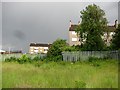
The Geograph project started in 2005 with the aim of publishing, organising and preserving representative images for every square kilometre of Great Britain, Ireland and the Isle of Man.

There are currently over 7.5m images from over14,400 individuals and you can help contribute to the project by visiting https://www.geograph.org.uk
Image Map
Images are licensed for reuse under creativecommons.org/licenses/by-sa/2.0
Notes
- Clicking on the map will re-center to the selected point.
- The higher the marker number, the further away the image location is from the centre of the postcode.
Image Listing (35 Images Found)
Images are licensed for reuse under creativecommons.org/licenses/by-sa/2.0
Image
Details
Distance
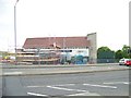
2
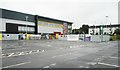
New Sports Direct building
The corner of the new purpose-built branch of Sports Direct beside Westerhouse Road.
This will be Sports Direct’s first completely new outlet in Scotland, housing all of the company’s retail operations under one roof.
Image: © Richard Sutcliffe
Taken: 12 Aug 2018
0.05 miles
3
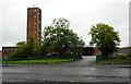
Easterhouse Baptist Church undergoing a refit
Image: © Elliott Simpson
Taken: 24 May 2009
0.05 miles
4
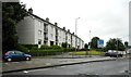
Arnisdale Road
Housing on Arnisdale Road, seen from Westerhouse Road.
Image: © Richard Webb
Taken: 16 Jun 2011
0.05 miles
5
New Sports Direct building
A new purpose-built branch of Sports Direct beside Morrisons supermarket nearing completion.
This will be Sports Direct’s first completely new outlet in Scotland, housing all of the company’s retail operations under one roof.
Image: © Richard Sutcliffe
Taken: 12 Aug 2018
0.06 miles
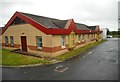
7

Arnisdale Road, Easterhouse
There has been some modernisation of the housing since this was taken. The small grassy hill once housed a triangulation pillar.
Image: © Richard Webb
Taken: 20 Apr 2005
0.06 miles
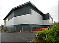
8
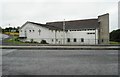
Easterhouse Community Health Centre
Part of the health centre complex.
Image: © Richard Sutcliffe
Taken: 12 Aug 2018
0.07 miles
9
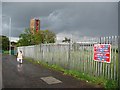
Westerhouse Road
Looking towards the fire station.
Image: © Richard Webb
Taken: 16 Jun 2011
0.08 miles