IMAGES TAKEN NEAR TO
Lochend Road, GLASGOW, G34 0NR
Introduction
This page details the photographs taken nearby to Lochend Road, G34 0NR by members of the Geograph project.
The Geograph project started in 2005 with the aim of publishing, organising and preserving representative images for every square kilometre of Great Britain, Ireland and the Isle of Man.

There are currently over 7.5m images from over14,400 individuals and you can help contribute to the project by visiting https://www.geograph.org.uk
Image Map
Images are licensed for reuse under creativecommons.org/licenses/by-sa/2.0
Notes
- Clicking on the map will re-center to the selected point.
- The higher the marker number, the further away the image location is from the centre of the postcode.
Image Listing (19 Images Found)
Images are licensed for reuse under creativecommons.org/licenses/by-sa/2.0
Image
Details
Distance
1
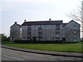
Lochend Road flats
Nicely redeveloped flats in Easterhouse.
Image: © Stephen Sweeney
Taken: 20 Apr 2009
0.03 miles
2
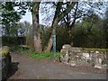
Woodland path to Craigend Wood
Off Lochend Road, Easterhouse.
Image: © Stephen Sweeney
Taken: 20 Apr 2009
0.10 miles
3
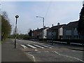
Zebra crossing
On Lochend Road, Easterhouse.
Image: © Stephen Sweeney
Taken: 20 Apr 2009
0.13 miles
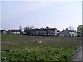
4
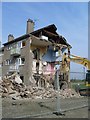
Demolition in Easterhouse
House being demolished on Lochend Road.
Image: © Stephen Sweeney
Taken: 20 Apr 2009
0.14 miles
5
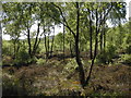
Craigend Wood
Birch trees in Craigend Wood.
Image: © Richard Sutcliffe
Taken: 29 May 2009
0.15 miles
7
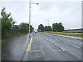
Bus stop on Westerhouse Road, Easterhouse
Looking south east.
Image: © JThomas
Taken: 29 Jun 2017
0.16 miles
8
Catholic church on Westerhouse Road
Not in Westerhouse, but in Easterhouse!
Image: © Stephen Sweeney
Taken: 20 Apr 2009
0.19 miles
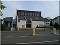
9
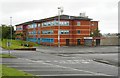
Easterhouse Social Work Area Office
Image: © Richard Sutcliffe
Taken: 12 Aug 2018
0.20 miles
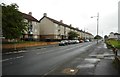
10
Baldragon Road
Residential street in Easterhouse.
Image: © Stephen Sweeney
Taken: 20 Apr 2009
0.20 miles