IMAGES TAKEN NEAR TO
Drumlanrig Avenue, GLASGOW, G34 0HW
Introduction
This page details the photographs taken nearby to Drumlanrig Avenue, G34 0HW by members of the Geograph project.
The Geograph project started in 2005 with the aim of publishing, organising and preserving representative images for every square kilometre of Great Britain, Ireland and the Isle of Man.

There are currently over 7.5m images from over14,400 individuals and you can help contribute to the project by visiting https://www.geograph.org.uk
Image Map
Images are licensed for reuse under creativecommons.org/licenses/by-sa/2.0
Notes
- Clicking on the map will re-center to the selected point.
- The higher the marker number, the further away the image location is from the centre of the postcode.
Image Listing (8 Images Found)
Images are licensed for reuse under creativecommons.org/licenses/by-sa/2.0
Image
Details
Distance
1
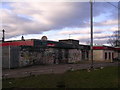
Ladbrokes, Easterhouse-style
A perfect spot for smashing those Buckfast bottles
Image: © Chris Upson
Taken: 26 Feb 2006
0.18 miles
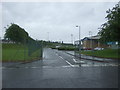
2
Cairnbrook Road, Easterhouse
Looking north east.
Image: © JThomas
Taken: 29 Jun 2017
0.19 miles

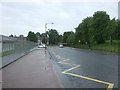
4
School entrance off Cairnbrook Road, Easterhouse
Image: © JThomas
Taken: 29 Jun 2017
0.20 miles
5
Baldragon Road
Residential street in Easterhouse.
Image: © Stephen Sweeney
Taken: 20 Apr 2009
0.22 miles
6
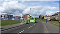
Lochdochart Road, Easterhouse
An X19 bus passes a new MUGA in a very much rebuilt Easterhouse.
Image: © Richard Webb
Taken: 23 Apr 2012
0.23 miles
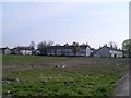
7
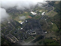
Easterhouse from the air
Lots of 'ghost streets' where houses once stood on the northern outskirts of Easterhouse.
Image: © Thomas Nugent
Taken: 5 May 2022
0.24 miles
8
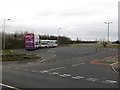
Bus Terminus, Easterhouse
At the corner of Lochend Road and Lochdochart Road.
Image: © G Laird
Taken: 10 Mar 2012
0.24 miles