IMAGES TAKEN NEAR TO
Denmilne Street, GLASGOW, G34 0AX
Introduction
This page details the photographs taken nearby to Denmilne Street, G34 0AX by members of the Geograph project.
The Geograph project started in 2005 with the aim of publishing, organising and preserving representative images for every square kilometre of Great Britain, Ireland and the Isle of Man.

There are currently over 7.5m images from over14,400 individuals and you can help contribute to the project by visiting https://www.geograph.org.uk
Image Map
Images are licensed for reuse under creativecommons.org/licenses/by-sa/2.0
Notes
- Clicking on the map will re-center to the selected point.
- The higher the marker number, the further away the image location is from the centre of the postcode.
Image Listing (2 Images Found)
Images are licensed for reuse under creativecommons.org/licenses/by-sa/2.0
Image
Details
Distance
1
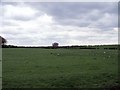
Commonhead Enclosure
Surrounded on two sides by roads and on the other by a burn this field was one of the first in Old Monkland parish to be 'enclosed' in the 'Agricultural Revolution' of the late 18th. and early 19th. centuries.
Image: © Robert Murray
Taken: 13 May 2010
0.23 miles
2

Easterhouse, Monkland Canal
The filled in route of the Monkland Canal strangled by vegetation looking east towards Netherhouse Bridge from the old village of West Merryston or the 'Hole' as it was usually known as.
Image: © Robert Murray
Taken: 27 Mar 2006
0.25 miles