IMAGES TAKEN NEAR TO
Denmilne Street, GLASGOW, G34 0AE
Introduction
This page details the photographs taken nearby to Denmilne Street, G34 0AE by members of the Geograph project.
The Geograph project started in 2005 with the aim of publishing, organising and preserving representative images for every square kilometre of Great Britain, Ireland and the Isle of Man.

There are currently over 7.5m images from over14,400 individuals and you can help contribute to the project by visiting https://www.geograph.org.uk
Image Map
Images are licensed for reuse under creativecommons.org/licenses/by-sa/2.0
Notes
- Clicking on the map will re-center to the selected point.
- The higher the marker number, the further away the image location is from the centre of the postcode.
Image Listing (20 Images Found)
Images are licensed for reuse under creativecommons.org/licenses/by-sa/2.0
Image
Details
Distance
1
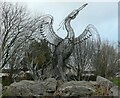
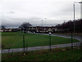
The Easterhouse Phoenix by Andy Scott
A sculpture which symbolises the regeneration of this area of Glasgow.
This photograph replicates the first image for the square Image photographed and submitted in 2006.
Image: © Richard Sutcliffe
Taken: 16 Dec 2021
0.16 miles
2
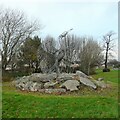
The Easterhouse Phoenix by Andy Scott
A sculpture which symbolises the regeneration of this area of Glasgow.
Image: © Richard Sutcliffe
Taken: 16 Dec 2021
0.16 miles
3
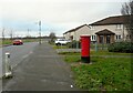
Pillar box, Aberdalgie Road
The pillar box is postbox number G34 1343.
Image: © Richard Sutcliffe
Taken: 16 Dec 2021
0.17 miles
4

Easterhouse Road
At its junction with the eastbound exit road from J9 of the M8, where it is called, for a short stretch, Rod Erick Lawson Terrace.
Image: © M J Richardson
Taken: 18 Aug 2010
0.17 miles
5
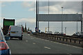
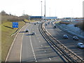
Glasgow City : The M8 Motorway
Heading out from Glasgow on the M8 motorway.
Image: © Lewis Clarke
Taken: 25 Apr 2016
0.17 miles
6
Easterhouse Road
Swordale Place is in the foreground, Easterhouse Road in the background.
Image: © Thomas Nugent
Taken: 6 Jan 2013
0.18 miles
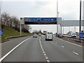
7
M8 at Junction 9
Looking east from the Easterhouse Road flyover towards the major intersection of the M8, M73 and A89. The 'get in lane sign' prior to the junction clearly visible in the foreground.
Image: © G Laird
Taken: 30 Jan 2010
0.18 miles
8
M8 Motorway
Overhead sign gantry and 300 metre contdown marker for junction 8 of the M8 motorway.
Note the typical “Glasgow-type” sign gantry with the following distinctive elements:
• Near and offside support legs (basically 2 rectangular hollow sections with base plates to allow connections to the foundations)
• A Main Frame (made up of rectangular hollow sections) - Over clad on the front and rear.
• A Sub Frame (made up of smaller hollow sections and welded to main frame).
• A Sign Face - acrylic sheets hung from the front of the sub frame over its full height.
• Internal Electrics - sign lighting provided through the use of several dozen fluorescent battens.
Gantries of this type were erected as part of the construction of the Kingston Bridge and its approach roads in 1970 and they are now a familiar sight on the network around Glasgow.
More information on “Glasgow Style Gantries” at http://www.glasgows-motorways.co.uk/glasgow-gantries/4578281645 (Glasgow’s Motorways)
Image: © David Dixon
Taken: 20 Apr 2012
0.18 miles
9

M8 Motorway, Easterhouse
Looking south east from the bridge on Easterhouse Road.
Image: © JThomas
Taken: 29 Jun 2017
0.18 miles
10
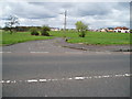
Ervie Street Easterhouse
Vacant land following demolition of Glasgow Corporation housing. Local Housing Association houses seen on right of picture.
Image: © Gordon Dowie
Taken: 29 Apr 2010
0.19 miles