IMAGES TAKEN NEAR TO
Snowdrop Path, GLASGOW, G33 6PR
Introduction
This page details the photographs taken nearby to Snowdrop Path, G33 6PR by members of the Geograph project.
The Geograph project started in 2005 with the aim of publishing, organising and preserving representative images for every square kilometre of Great Britain, Ireland and the Isle of Man.

There are currently over 7.5m images from over14,400 individuals and you can help contribute to the project by visiting https://www.geograph.org.uk
Image Map
Images are licensed for reuse under creativecommons.org/licenses/by-sa/2.0
Notes
- Clicking on the map will re-center to the selected point.
- The higher the marker number, the further away the image location is from the centre of the postcode.
Image Listing (18 Images Found)
Images are licensed for reuse under creativecommons.org/licenses/by-sa/2.0
Image
Details
Distance
2
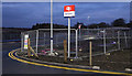
Robroyston railway station
The station sign by the new road at the north side of the station.
Image: © Thomas Nugent
Taken: 24 Dec 2019
0.14 miles
3

New road at Robroyston railway station
An incomplete stretch of road, near the bus turning circle at the north side of the station.
Image: © Thomas Nugent
Taken: 24 Dec 2019
0.15 miles
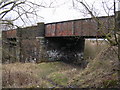
4

Bridges near Robroyston railway station
The two bridges cross the route of the former Caledonian line which served a marshalling yard and several colliery branches. This is the location of the former Robroyston East Junction, immediately east of the recently opened Robroyston station.
Image: © Thomas Nugent
Taken: 24 Dec 2019
0.17 miles
5

Bridges near Robroyston railway station
The bridge on the right crosses the existing Glasgow to Edinburgh via Cumbernauld line immediately east of Robroyston station. The two bridges on the left cross the route of the former Caledonian line which served a marshalling yard and several colliery branches. This is the location of the former Robroyston East Junction.
Image: © Thomas Nugent
Taken: 24 Dec 2019
0.17 miles
6

Robroyston railway station
The car park on the north side of the station.
Image: © Thomas Nugent
Taken: 24 Dec 2019
0.19 miles
7
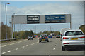
Glasgow City : The M80 Motorway
Heading into the city of Glasgow on the M80.
Image: © Lewis Clarke
Taken: 25 Apr 2016
0.19 miles
8
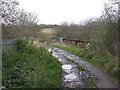
Old Bridge North of Millerston
Looking along the muddy dirt track known as Bogside Road at the point where it crosses a main railway line into Glasgow.
Image: © G Laird
Taken: 22 Oct 2011
0.19 miles
9

Robroyston railway station
Wheelchair accessible parking spaces beside Platform 2 on the north side of the station.
Image: © Thomas Nugent
Taken: 24 Dec 2019
0.19 miles
10

Robroyston railway station
Glasgow bound Scotrail Class 385 train number 385 026 is at Platform 1.
Image: © Thomas Nugent
Taken: 24 Dec 2019
0.20 miles