IMAGES TAKEN NEAR TO
Orchid Grove, G33 6PP
Introduction
This page details the photographs taken nearby to Orchid Grove, G33 6PP by members of the Geograph project.
The Geograph project started in 2005 with the aim of publishing, organising and preserving representative images for every square kilometre of Great Britain, Ireland and the Isle of Man.

There are currently over 7.5m images from over14,400 individuals and you can help contribute to the project by visiting https://www.geograph.org.uk
Image Map
Images are licensed for reuse under creativecommons.org/licenses/by-sa/2.0
Notes
- Clicking on the map will re-center to the selected point.
- The higher the marker number, the further away the image location is from the centre of the postcode.
Image Listing (5 Images Found)
Images are licensed for reuse under creativecommons.org/licenses/by-sa/2.0
Image
Details
Distance
1
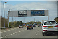
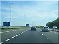
Glasgow City : The M80 Motorway
Heading into the city of Glasgow on the M80.
Image: © Lewis Clarke
Taken: 25 Apr 2016
0.10 miles
4

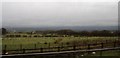
Saughs Farm (ruin) near Stepps Bypass
Remains of Saughs Farm, very close to south-bound carriageway of the M80.
Image: © Texas Radio and The Big Beat
Taken: 17 Oct 2009
0.21 miles