IMAGES TAKEN NEAR TO
McNab Crescent, GLASGOW, G33 6NY
Introduction
This page details the photographs taken nearby to McNab Crescent, G33 6NY by members of the Geograph project.
The Geograph project started in 2005 with the aim of publishing, organising and preserving representative images for every square kilometre of Great Britain, Ireland and the Isle of Man.

There are currently over 7.5m images from over14,400 individuals and you can help contribute to the project by visiting https://www.geograph.org.uk
Image Map
Images are licensed for reuse under creativecommons.org/licenses/by-sa/2.0
Notes
- Clicking on the map will re-center to the selected point.
- The higher the marker number, the further away the image location is from the centre of the postcode.
Image Listing (9 Images Found)
Images are licensed for reuse under creativecommons.org/licenses/by-sa/2.0
Image
Details
Distance
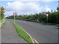
1
Roundabout at Dewar Road
From Kilpatrick Drive. The pylons in the southeast corner of the square can be seen running along in the background.
Image: © Stephen Sweeney
Taken: 9 Sep 2009
0.07 miles
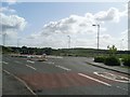
2
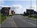
Roundabout at The Hawthorns
This is a new, second roundabout that doesn't even appear on the maps at the periphery of this new housing development
Image: © Darrin Antrobus
Taken: 15 May 2007
0.11 miles
3
Dewar Road
Leads north towards the M80.
Image: © Stephen Sweeney
Taken: 9 Sep 2009
0.14 miles
4
Speed humps on Kilpatrick Drive
Nearing the roundabout at Dewar Road.
Image: © Stephen Sweeney
Taken: 9 Sep 2009
0.15 miles
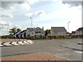
5
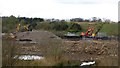
Construction, Cardowan
Groundworks in progress at the site of the Cardowan fireclay works.
Image: © Richard Webb
Taken: 23 Apr 2012
0.16 miles
6
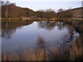
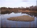
Loch at disused Cardowan Fireclay Works
Some history of the fireclay works here
http://www.monklands.co.uk/glenathill/garnkirk.htm
Image: © Chris Upson
Taken: 17 Feb 2006
0.18 miles
7
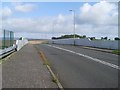
Road bridge across the railway
Takes Dewar Road over the railway line between Stepps and Gartcosh stations.
Image: © Stephen Sweeney
Taken: 9 Sep 2009
0.21 miles
8
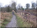
Path and Railway
The path leads to Stepps from Garnkirk.
The railway is a stretch of the Cumbernauld line between Stepps and Gartcosh railway stations.
Image: © G Laird
Taken: 1 Jan 2014
0.21 miles