IMAGES TAKEN NEAR TO
Station Road, GLASGOW, G33 6HB
Introduction
This page details the photographs taken nearby to Station Road, G33 6HB by members of the Geograph project.
The Geograph project started in 2005 with the aim of publishing, organising and preserving representative images for every square kilometre of Great Britain, Ireland and the Isle of Man.

There are currently over 7.5m images from over14,400 individuals and you can help contribute to the project by visiting https://www.geograph.org.uk
Image Map
Images are licensed for reuse under creativecommons.org/licenses/by-sa/2.0
Notes
- Clicking on the map will re-center to the selected point.
- The higher the marker number, the further away the image location is from the centre of the postcode.
Image Listing (15 Images Found)
Images are licensed for reuse under creativecommons.org/licenses/by-sa/2.0
Image
Details
Distance
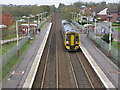
2
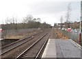
Stepps Road railway station (site), North Lanarkshire
Opened in 1831 by the Garnkirk & Glasgow Railway (needs confirmation), later part of the Caledonian Railway, this station was originally called 'Steps Road'. It closed in 1962.
View west towards Robroyston and Glasgow, before electrification. The station was just before the bridge, and to the right, where the houses now are, was a carriage shed, later carriage sidings. In 1989, British Rail opened a replacement station - see Image
Image: © Nigel Thompson
Taken: 15 Mar 2013
0.07 miles
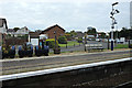
3
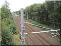
Stepps Road railway station (site), North Lanarkshire
Opened in 1831 by the Garnkirk & Glasgow Railway (needs confirmation), later part of the Caledonian Railway, this station was originally called 'Steps Road'. It closed in 1962.
View east towards the replacement Stepps station opened in 1989, and Edinburgh.
Image: © Nigel Thompson
Taken: 25 Aug 2016
0.08 miles
6
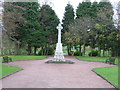
Stepps War Memorial
First and Second World War Memorial just North of Cumbernauld Road.
Image: © G Laird
Taken: 22 Oct 2011
0.11 miles
7
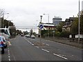
Cumbernauld Road, Stepps (A80)
The footbridge would have been even more useful before the M80 when this was the main road out of Glasgow in the direction of Cumbernauld, Stirlingshire and beyond.
Image: © Richard Webb
Taken: 14 Oct 2011
0.13 miles
8
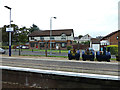
Stepps railway station
A "Barry the Barrel" floral display on the northbound platform.
Image: © Thomas Nugent
Taken: 10 Oct 2015
0.20 miles
9
Stepps Railway Station
Viewed from the bridge carrying Cardowan Road.
Image: © G Laird
Taken: 22 Oct 2011
0.21 miles
10
Stepps railway station
The top of Buchanan Tower at the former Black & Whyte distillery site can be seen in the distance.
Image: © Thomas Nugent
Taken: 10 Oct 2015
0.21 miles