IMAGES TAKEN NEAR TO
Cardowan Road, GLASGOW, G33 6AW
Introduction
This page details the photographs taken nearby to Cardowan Road, G33 6AW by members of the Geograph project.
The Geograph project started in 2005 with the aim of publishing, organising and preserving representative images for every square kilometre of Great Britain, Ireland and the Isle of Man.

There are currently over 7.5m images from over14,400 individuals and you can help contribute to the project by visiting https://www.geograph.org.uk
Image Map (23 Images)


Getting Data...Please wait
Leaflet Map data © OpenStreetMap
Images are licensed for reuse under creativecommons.org/licenses/by-sa/2.0
Notes
- Clicking on the map will re-center to the selected point.
- The higher the marker number, the further away the image location is from the centre of the postcode.
Image Listing (23 Images Found)
Images are licensed for reuse under creativecommons.org/licenses/by-sa/2.0
Image
Details
Distance
1
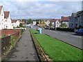
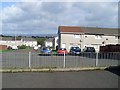
Cardowan Road
Looking north towards St Joseph's Church.
Image: © Stephen Sweeney
Taken: 9 Sep 2009
0.05 miles
2
St Joseph's Parish Old School Centre
Next to the parish church.
Image: © Stephen Sweeney
Taken: 9 Sep 2009
0.07 miles
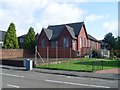
3
Brown Court, Stepps
Part of the new development east of Cardowan Road.
Image: © Stephen Sweeney
Taken: 9 Sep 2009
0.11 miles
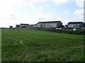
5

Comedie Road, Cardowan
The site of a long since demolished triangulation pillar.
Image: © Richard Webb
Taken: 20 Apr 2005
0.19 miles
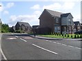
6
Mossview Road from Clayhouse Road
Looking into the residential area.
Image: © Stephen Sweeney
Taken: 9 Sep 2009
0.19 miles
7
Looking towards Comedie Road
From the path by Clayhouse Road.
Image: © Stephen Sweeney
Taken: 9 Sep 2009
0.20 miles
8
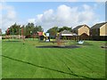
Playpark by Kilpatrick Drive
In Stepps.
Image: © Stephen Sweeney
Taken: 9 Sep 2009
0.20 miles
9
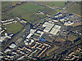
Buchanan Business Park from the air
The former Black & Whyte works of distillers James Buchanan & Co. The tower looks like an office building, but was designed to store up to 20,000 casks of whisky on ten floors. Closed in 1987 and now part of the business park.
See also Image
Image: © Thomas Nugent
Taken: 9 Feb 2018
0.22 miles
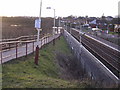
10
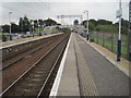
Stepps railway station, North Lanarkshire
Opened in 1989 by British Rail on the line from Glasgow to Cumbernauld. View east towards Garnkirk and Cumbernauld.
An earlier station at 'Steps Road' had been provided by the Garnkirk & Glasgow Railway some 200m west of here, behind the camera position. This opened in 1831 but closed in 1962 (needs confirmation).
The line has been electrified since Image] was taken from the opposite platform.
Image: © Nigel Thompson
Taken: 25 Aug 2016
0.22 miles