IMAGES TAKEN NEAR TO
Clayhouse Road, GLASGOW, G33 6AN
Introduction
This page details the photographs taken nearby to Clayhouse Road, G33 6AN by members of the Geograph project.
The Geograph project started in 2005 with the aim of publishing, organising and preserving representative images for every square kilometre of Great Britain, Ireland and the Isle of Man.

There are currently over 7.5m images from over14,400 individuals and you can help contribute to the project by visiting https://www.geograph.org.uk
Image Map
Images are licensed for reuse under creativecommons.org/licenses/by-sa/2.0
Notes
- Clicking on the map will re-center to the selected point.
- The higher the marker number, the further away the image location is from the centre of the postcode.
Image Listing (20 Images Found)
Images are licensed for reuse under creativecommons.org/licenses/by-sa/2.0
Image
Details
Distance
1
Cardowan Road
Looking north towards St Joseph's Church.
Image: © Stephen Sweeney
Taken: 9 Sep 2009
0.10 miles
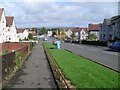
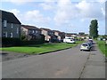
2
Mossview Road from Clayhouse Road
Looking into the residential area.
Image: © Stephen Sweeney
Taken: 9 Sep 2009
0.11 miles
3

Comedie Road, Cardowan
The site of a long since demolished triangulation pillar.
Image: © Richard Webb
Taken: 20 Apr 2005
0.11 miles
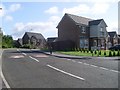
4
Looking towards Comedie Road
From the path by Clayhouse Road.
Image: © Stephen Sweeney
Taken: 9 Sep 2009
0.13 miles
5
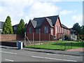
St Joseph's Parish Old School Centre
Next to the parish church.
Image: © Stephen Sweeney
Taken: 9 Sep 2009
0.13 miles
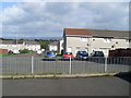
7
Brown Court, Stepps
Part of the new development east of Cardowan Road.
Image: © Stephen Sweeney
Taken: 9 Sep 2009
0.17 miles
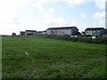
8
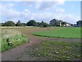
Football pitches at Cardowan
By Clayhouse Road.
Image: © Stephen Sweeney
Taken: 9 Sep 2009
0.17 miles
10
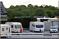
Craigendmuir Caravan Park
Lower hard standing area for tourers.
Image: © Jo and Steve Turner
Taken: 4 Jun 2012
0.20 miles