IMAGES TAKEN NEAR TO
Jerviston Road, GLASGOW, G33 5QL
Introduction
This page details the photographs taken nearby to Jerviston Road, G33 5QL by members of the Geograph project.
The Geograph project started in 2005 with the aim of publishing, organising and preserving representative images for every square kilometre of Great Britain, Ireland and the Isle of Man.

There are currently over 7.5m images from over14,400 individuals and you can help contribute to the project by visiting https://www.geograph.org.uk
Image Map
Images are licensed for reuse under creativecommons.org/licenses/by-sa/2.0
Notes
- Clicking on the map will re-center to the selected point.
- The higher the marker number, the further away the image location is from the centre of the postcode.
Image Listing (7 Images Found)
Images are licensed for reuse under creativecommons.org/licenses/by-sa/2.0
Image
Details
Distance
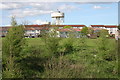
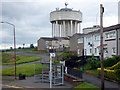
1
Kilchoan Road
Row of terraces with the Craigend and Garthamlock water towers in the background. Taken just before a sharp hailstorm.
Image: © Richard Webb
Taken: 16 Jun 2011
0.06 miles
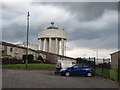
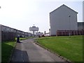
3
Craigend and Garthamlock Water Towers
Prominent water towers visible from the M8, here caught in late afternoon sunshine
Image: © Chris Upson
Taken: 18 Nov 2005
0.12 miles
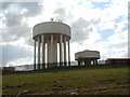
4
Water towers, Garthamlock
Viewed from close to the M8 Motorway.
Image: © Richard Sutcliffe
Taken: 5 May 2006
0.12 miles
5
Collessie Drive
The Garthamlock water towers dominate the scene.
Image: © Thomas Nugent
Taken: 17 Jun 2018
0.13 miles
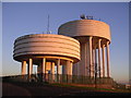
6
Craigend Water Towers from Riggside Road
Image: © Stephen Sweeney
Taken: 20 Apr 2009
0.13 miles
7
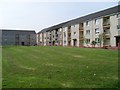
Glenraith Square
Residential street in Craigend, Glasgow.
Image: © Stephen Sweeney
Taken: 20 Apr 2009
0.24 miles