IMAGES TAKEN NEAR TO
Sandaig Road, GLASGOW, G33 4SY
Introduction
This page details the photographs taken nearby to Sandaig Road, G33 4SY by members of the Geograph project.
The Geograph project started in 2005 with the aim of publishing, organising and preserving representative images for every square kilometre of Great Britain, Ireland and the Isle of Man.

There are currently over 7.5m images from over14,400 individuals and you can help contribute to the project by visiting https://www.geograph.org.uk
Image Map
Images are licensed for reuse under creativecommons.org/licenses/by-sa/2.0
Notes
- Clicking on the map will re-center to the selected point.
- The higher the marker number, the further away the image location is from the centre of the postcode.
Image Listing (9 Images Found)
Images are licensed for reuse under creativecommons.org/licenses/by-sa/2.0
Image
Details
Distance
1
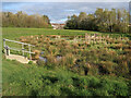
Biodiversity 'scrape' in Early Braes Park
Biodiversity 'scrapes' are shallow depressions of land which hold variable depths of water to create wet habitat features for wildlife. They support a wide variety of invertebrates and can provide important feeding areas for breeding wading birds and their chicks. This one is also a part of the Garrowhill Surface Water Management Plan (SWMP) by providing additional floodplain storage capacity.
Image: © wrobison
Taken: 20 Apr 2024
0.17 miles
2
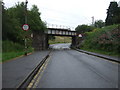
Railway bridge over Glenduffhill Road
Near Garrowhill Railway Station.
Image: © JThomas
Taken: 29 Jun 2017
0.20 miles
3
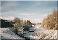
Tollcross Burn at Glenduffhill
This burn which has a few different names along its route flows through what must have been a nice little glen before coal mining, the railway and housing encroached upon it.
Image: © Robert Murray
Taken: 27 Jan 2003
0.20 miles
7
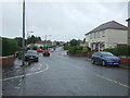
Barrachnie Road (B7058)
Looking north east.
Image: © JThomas
Taken: 29 Jun 2017
0.25 miles
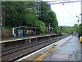
9
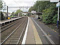
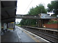
Garrowhill railway station, Glasgow
Opened in 1936 by the London Midland & Scottish Railway on what is now the line from Glasgow Queen Street Low Level to Edinburgh via Bathgate.
View east towards Easterhouse and Edinburgh
Image: © Nigel Thompson
Taken: 4 Oct 2013
0.25 miles