IMAGES TAKEN NEAR TO
Garvel Road, GLASGOW, G33 4PP
Introduction
This page details the photographs taken nearby to Garvel Road, G33 4PP by members of the Geograph project.
The Geograph project started in 2005 with the aim of publishing, organising and preserving representative images for every square kilometre of Great Britain, Ireland and the Isle of Man.

There are currently over 7.5m images from over14,400 individuals and you can help contribute to the project by visiting https://www.geograph.org.uk
Image Map
Images are licensed for reuse under creativecommons.org/licenses/by-sa/2.0
Notes
- Clicking on the map will re-center to the selected point.
- The higher the marker number, the further away the image location is from the centre of the postcode.
Image Listing (11 Images Found)
Images are licensed for reuse under creativecommons.org/licenses/by-sa/2.0
Image
Details
Distance
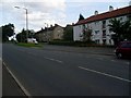
1
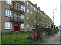
Flats in Garvel Road, G33
Shows the location of Image
Image: © Mike Quinn
Taken: 21 Oct 2010
0.01 miles
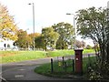
2
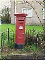
Edward VIII postbox, Garvel Road / Barlanark Road, G33
Image: © Mike Quinn
Taken: 21 Oct 2010
0.04 miles
3
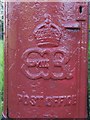
Edward VIII postbox, Garvel Road / Barlanark Road, G33 - royal cipher
See Image
Image: © Mike Quinn
Taken: 21 Oct 2010
0.04 miles
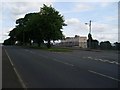
4
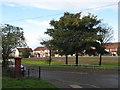
Open space, Garvel Road / Barlanark Road, G33
Shows the location of Image
Image: © Mike Quinn
Taken: 21 Oct 2010
0.05 miles
7
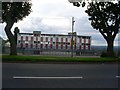
Wellhouse Primary School
Seen from Bartiebeith Road.
Image: © Stephen Sweeney
Taken: 16 Aug 2008
0.20 miles
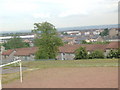
9
Housing just off Bartiebeith Road
Surrounding Inver Road.
Image: © Stephen Sweeney
Taken: 16 Aug 2008
0.22 miles
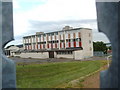
10
Wellhouse Primary School
From Bartiebeith Road.
Image: © Stephen Sweeney
Taken: 16 Aug 2008
0.23 miles