IMAGES TAKEN NEAR TO
Stepford Road, GLASGOW, G33 4PB
Introduction
This page details the photographs taken nearby to Stepford Road, G33 4PB by members of the Geograph project.
The Geograph project started in 2005 with the aim of publishing, organising and preserving representative images for every square kilometre of Great Britain, Ireland and the Isle of Man.

There are currently over 7.5m images from over14,400 individuals and you can help contribute to the project by visiting https://www.geograph.org.uk
Image Map
Images are licensed for reuse under creativecommons.org/licenses/by-sa/2.0
Notes
- Clicking on the map will re-center to the selected point.
- The higher the marker number, the further away the image location is from the centre of the postcode.
Image Listing (16 Images Found)
Images are licensed for reuse under creativecommons.org/licenses/by-sa/2.0
Image
Details
Distance
1
Shops on Wardie Road
Post Office now closed.
Image: © JThomas
Taken: 29 Jun 2017
0.07 miles
3
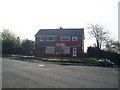
Stepford Wives?
Housing in an area in Glasgow's East End, on a road called Stepford Road.
Image: © Stephen Sweeney
Taken: 20 Apr 2009
0.11 miles
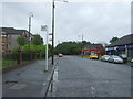
4
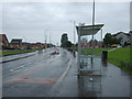
Bus stop and shelter on Wellhouse Road
Looking north.
Image: © JThomas
Taken: 29 Jun 2017
0.11 miles
5
Vito's
Fast food take-away on Edinburgh Road.
Image: © Stephen Sweeney
Taken: 20 Apr 2009
0.12 miles
6
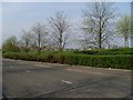
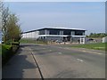
Landscaping at Glasgow Business Park
Next to Springhill Parkway.
Image: © Stephen Sweeney
Taken: 20 Apr 2009
0.12 miles
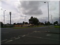
7
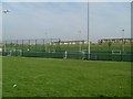
Seven-a-side football pitches by Edinburgh Road
Image: © Stephen Sweeney
Taken: 20 Apr 2009
0.14 miles
8

Houses on Langbar Crescent
View from Wellhouse Road.
Image: © JThomas
Taken: 29 Jun 2017
0.14 miles
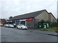
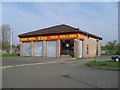
9
Flanagan Flooring
Business premises in Glasgow Business Park.
Image: © Stephen Sweeney
Taken: 20 Apr 2009
0.15 miles