IMAGES TAKEN NEAR TO
Baldovan Crescent, GLASGOW, G33 4LR
Introduction
This page details the photographs taken nearby to Baldovan Crescent, G33 4LR by members of the Geograph project.
The Geograph project started in 2005 with the aim of publishing, organising and preserving representative images for every square kilometre of Great Britain, Ireland and the Isle of Man.

There are currently over 7.5m images from over14,400 individuals and you can help contribute to the project by visiting https://www.geograph.org.uk
Image Map
Images are licensed for reuse under creativecommons.org/licenses/by-sa/2.0
Notes
- Clicking on the map will re-center to the selected point.
- The higher the marker number, the further away the image location is from the centre of the postcode.
Image Listing (10 Images Found)
Images are licensed for reuse under creativecommons.org/licenses/by-sa/2.0
Image
Details
Distance
1
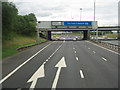
M8, J10, heading east
The exit for Springhill and Easterhouse. The bridge beyond the gantry sign carries Westerhouse Road.
Image: © M J Richardson
Taken: 24 Aug 2013
0.11 miles
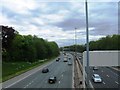
3
Glasgow City : The M8 Motorway
Heading along the M8 through Glasgow.
Image: © Lewis Clarke
Taken: 25 Apr 2016
0.13 miles
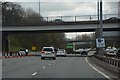
4
M8 near Glasgow Fort
Looking west along the M8 at Junction 10 towards the Glasgow Fort Shopping Centre.
Image: © G Laird
Taken: 30 May 2009
0.19 miles
5
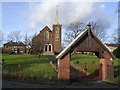
St John Ogilvie, Roman Catholic Church
On Newhills Road / Wellhouse Crescent, Easterhouse
Image: © Chris Upson
Taken: 17 Feb 2006
0.19 miles
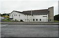
7
Easterhouse Baptist Church undergoing a refit
Image: © Elliott Simpson
Taken: 24 May 2009
0.21 miles

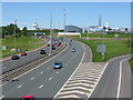
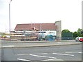
10
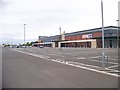
A supermarket and space for further development at Glasgow Fort
Image: © Elliott Simpson
Taken: 24 May 2009
0.25 miles