IMAGES TAKEN NEAR TO
Weardale Street, GLASGOW, G33 4DA
Introduction
This page details the photographs taken nearby to Weardale Street, G33 4DA by members of the Geograph project.
The Geograph project started in 2005 with the aim of publishing, organising and preserving representative images for every square kilometre of Great Britain, Ireland and the Isle of Man.

There are currently over 7.5m images from over14,400 individuals and you can help contribute to the project by visiting https://www.geograph.org.uk
Image Map
Images are licensed for reuse under creativecommons.org/licenses/by-sa/2.0
Notes
- Clicking on the map will re-center to the selected point.
- The higher the marker number, the further away the image location is from the centre of the postcode.
Image Listing (3 Images Found)
Images are licensed for reuse under creativecommons.org/licenses/by-sa/2.0
Image
Details
Distance
1
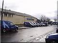
Queenslie Training Centre, Glasgow City Council
The training centre is in Queenslie, close to junction 11 of the M8 in the east end of Glasgow.
In the foreground are a number of Scottish Gas vans as their depot is next door to the training centre.
Image: © G McK
Taken: 20 Jan 2006
0.15 miles
2
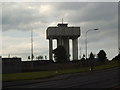
Tower near the Queenslie Industrial Estate
Image: © Darrin Antrobus
Taken: 1 Jun 2007
0.20 miles
3
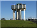
Cranhill Water Tower
The 98ft water tower at the corner of Stepps Road and Bellrock Street dominates the Cranhill skyline
It was one of several huge elevated storage tanks built to provide high-volume, high-pressure storage for the homes on the housing estate.
Image: © G Laird
Taken: 30 Jan 2010
0.20 miles