IMAGES TAKEN NEAR TO
G33 3XE
Introduction
This page details the photographs taken nearby to G33 3XE by members of the Geograph project.
The Geograph project started in 2005 with the aim of publishing, organising and preserving representative images for every square kilometre of Great Britain, Ireland and the Isle of Man.

There are currently over 7.5m images from over14,400 individuals and you can help contribute to the project by visiting https://www.geograph.org.uk
Image Map
Images are licensed for reuse under creativecommons.org/licenses/by-sa/2.0
Notes
- Clicking on the map will re-center to the selected point.
- The higher the marker number, the further away the image location is from the centre of the postcode.
Image Listing (19 Images Found)
Images are licensed for reuse under creativecommons.org/licenses/by-sa/2.0
Image
Details
Distance
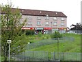
2
Gap site, Cranhill
Site of a demolished building
Image: © Richard Webb
Taken: 16 Jun 2011
0.08 miles
3
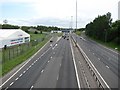
M8
Looking eastwards towards junction 11.
Image: © Richard Webb
Taken: 16 Jun 2011
0.13 miles
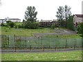
5
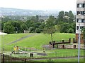
Beneath the towers
Park surrounding two tower blocks in Cranhill.
Image: © Richard Webb
Taken: 16 Jun 2011
0.14 miles
6
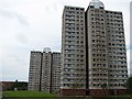
Tower blocks, Cranhill
With a scenic view of the M8. I used to live in a similar structure overlooking the M6 - you get an insufferable smugness looking down on someone else's traffic jam.
The structures at the top were added in a refurbishment sometime around 1990.
Image: © Richard Webb
Taken: 16 Jun 2011
0.15 miles
7
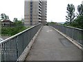
Footbridge over the M8
Bridge connecting Cranhill with Ruchazie.
Image: © Richard Webb
Taken: 16 Jun 2011
0.15 miles
8
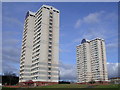
Cranhill Tower Blocks
Tower blocks with 17 floors of accommodation
Image: © Chris Upson
Taken: 17 Feb 2006
0.15 miles
9
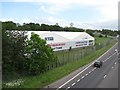
Five a side football
Indoor football facility beside the M8.
Image: © Richard Webb
Taken: 16 Jun 2011
0.16 miles
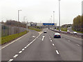
10
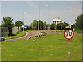
M8, exit 11
To the B765, Stepps Road, and Garthamlock and Queenslie, with the water tower at Craigend in the next square.
Image: © M J Richardson
Taken: 7 Jul 2013
0.20 miles