IMAGES TAKEN NEAR TO
Fastnet Street, GLASGOW, G33 3HS
Introduction
This page details the photographs taken nearby to Fastnet Street, G33 3HS by members of the Geograph project.
The Geograph project started in 2005 with the aim of publishing, organising and preserving representative images for every square kilometre of Great Britain, Ireland and the Isle of Man.

There are currently over 7.5m images from over14,400 individuals and you can help contribute to the project by visiting https://www.geograph.org.uk
Image Map
Images are licensed for reuse under creativecommons.org/licenses/by-sa/2.0
Notes
- Clicking on the map will re-center to the selected point.
- The higher the marker number, the further away the image location is from the centre of the postcode.
Image Listing (14 Images Found)
Images are licensed for reuse under creativecommons.org/licenses/by-sa/2.0
Image
Details
Distance
1
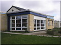
Ruchazie Community Church
The view of the community cafe at the local church. The bacon rolls smell good.
Image: © Sandy Gemmill
Taken: 31 Mar 2009
0.10 miles
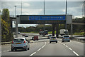
2
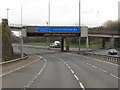
Sign Gantry, M8
The typical "Glasgow-style" overhead sign gantry on the M8, just to the west of the bridge carrying Gartcraig Road over the motorway.
Gantries of this type, with the following distinctive elements:
• near and offside support legs (basically 2 rectangular hollow sections with base plates to allow connections to the foundations),
• a Main Frame (made up of rectangular hollow sections) - Over clad on the front and rear,
• a Sub Frame (made up of smaller hollow sections and welded to main frame),
• a Sign Face - acrylic sheets hung from the front of the sub frame over its full height,
• internal Electrics - sign lighting provided through the use of several dozen fluorescent battens,
were first erected as part of the construction of the Kingston Bridge and its approach roads in 1970 and they are now a familiar sight with more than 100 examples on the network around Glasgow.
Image: © David Dixon
Taken: 20 Apr 2012
0.14 miles
4
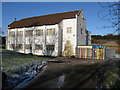
Cranhill Parish Church
On Bellrock Street, Cranhill, Glasgow. http://cranhillchurch.org.uk/index.php
Image: © G Laird
Taken: 30 Jan 2010
0.17 miles
5
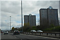
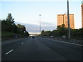
Glasgow City : The M8 Motorway
Heading along the M8 with some tower blocks on the right.
Image: © Lewis Clarke
Taken: 25 Apr 2016
0.17 miles
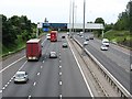
6
Glasgow City : The M8 Motorway
The M8 is the busiest motorway in Scotland and one of the busiest in the United Kingdom.
Image: © Lewis Clarke
Taken: 25 Apr 2016
0.18 miles
7
M8
Looking westward from a footbridge. As usual in Scotland, the variable message signs carry a road safety message. These can be bizarre and contrived - "Driving in Winter - blah blah" in April or "Comply with red X" but in this case it is just "fasten your seatbelt".
Image: © Richard Webb
Taken: 16 Jun 2011
0.19 miles
9
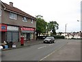
Star Discount Store
Shop on Bellrock Street.
Image: © Richard Webb
Taken: 16 Jun 2011
0.22 miles
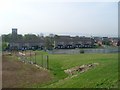
10
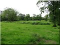
Park, Ruchazie
A grass and woodland park just north of the M8
Image: © Richard Webb
Taken: 16 Jun 2011
0.22 miles