IMAGES TAKEN NEAR TO
Roseness Place, GLASGOW, G33 3GB
Introduction
This page details the photographs taken nearby to Roseness Place, G33 3GB by members of the Geograph project.
The Geograph project started in 2005 with the aim of publishing, organising and preserving representative images for every square kilometre of Great Britain, Ireland and the Isle of Man.

There are currently over 7.5m images from over14,400 individuals and you can help contribute to the project by visiting https://www.geograph.org.uk
Image Map
Images are licensed for reuse under creativecommons.org/licenses/by-sa/2.0
Notes
- Clicking on the map will re-center to the selected point.
- The higher the marker number, the further away the image location is from the centre of the postcode.
Image Listing (5 Images Found)
Images are licensed for reuse under creativecommons.org/licenses/by-sa/2.0
Image
Details
Distance
1
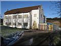
Cranhill Parish Church
On Bellrock Street, Cranhill, Glasgow. http://cranhillchurch.org.uk/index.php
Image: © G Laird
Taken: 30 Jan 2010
0.21 miles
3
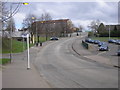
Carntyne Grove
Residential street in Carntyne.
Image: © Stephen Sweeney
Taken: 21 Apr 2009
0.21 miles
4
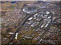
Cranhill from the air
The M8 motorway is on the left, Edinburgh Road is on the right. The U shaped cluster of buildings is the Fort shopping centre.
Image: © Thomas Nugent
Taken: 19 Mar 2018
0.23 miles
5
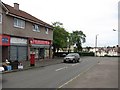
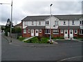
Star Discount Store
Shop on Bellrock Street.
Image: © Richard Webb
Taken: 16 Jun 2011
0.25 miles