IMAGES TAKEN NEAR TO
Lethamhill Road, GLASGOW, G33 2SQ
Introduction
This page details the photographs taken nearby to Lethamhill Road, G33 2SQ by members of the Geograph project.
The Geograph project started in 2005 with the aim of publishing, organising and preserving representative images for every square kilometre of Great Britain, Ireland and the Isle of Man.

There are currently over 7.5m images from over14,400 individuals and you can help contribute to the project by visiting https://www.geograph.org.uk
Image Map
Images are licensed for reuse under creativecommons.org/licenses/by-sa/2.0
Notes
- Clicking on the map will re-center to the selected point.
- The higher the marker number, the further away the image location is from the centre of the postcode.
Image Listing (8 Images Found)
Images are licensed for reuse under creativecommons.org/licenses/by-sa/2.0
Image
Details
Distance
1
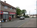
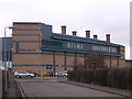
Star Discount Store
Shop on Bellrock Street.
Image: © Richard Webb
Taken: 16 Jun 2011
0.12 miles
2
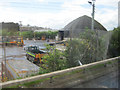
Gartcraig Depot by M8 westbound
This is a Glasgow City Council depot. In the background is Barlinnie prison
Image: © John Firth
Taken: 9 May 2011
0.16 miles
3
Glasgow City : The M8 Motorway
The M8 is the busiest motorway in Scotland and one of the busiest in the United Kingdom.
Image: © Lewis Clarke
Taken: 25 Apr 2016
0.19 miles
4
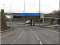
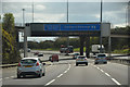
Sign Gantry, M8
The typical "Glasgow-style" overhead sign gantry on the M8, just to the west of the bridge carrying Gartcraig Road over the motorway.
Gantries of this type, with the following distinctive elements:
• near and offside support legs (basically 2 rectangular hollow sections with base plates to allow connections to the foundations),
• a Main Frame (made up of rectangular hollow sections) - Over clad on the front and rear,
• a Sub Frame (made up of smaller hollow sections and welded to main frame),
• a Sign Face - acrylic sheets hung from the front of the sub frame over its full height,
• internal Electrics - sign lighting provided through the use of several dozen fluorescent battens,
were first erected as part of the construction of the Kingston Bridge and its approach roads in 1970 and they are now a familiar sight with more than 100 examples on the network around Glasgow.
Image: © David Dixon
Taken: 20 Apr 2012
0.20 miles
5
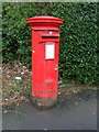
Elizabethan postbox on Gartcraig Road
Postbox No. G33 1038.
See Image] for context.
Image: © JThomas
Taken: 30 Mar 2017
0.22 miles
6
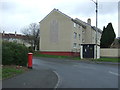
Gartcraig Road
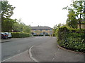
Showing position of Postbox No. G33 1038.
See Image] for postbox.
Image: © JThomas
Taken: 30 Mar 2017
0.22 miles
7
Barlinnie Prison
Once home to Abdel Baset al-Megrahi, convicted for the 1988 Lockerbie bombing which killed 270 people. http://www.geo.ed.ac.uk/scotgaz/features/featurefirst7716.html
Image: © Chris Upson
Taken: 24 Feb 2006
0.23 miles