IMAGES TAKEN NEAR TO
Lethamhill Road, GLASGOW, G33 2SF
Introduction
This page details the photographs taken nearby to Lethamhill Road, G33 2SF by members of the Geograph project.
The Geograph project started in 2005 with the aim of publishing, organising and preserving representative images for every square kilometre of Great Britain, Ireland and the Isle of Man.

There are currently over 7.5m images from over14,400 individuals and you can help contribute to the project by visiting https://www.geograph.org.uk
Image Map
Images are licensed for reuse under creativecommons.org/licenses/by-sa/2.0
Notes
- Clicking on the map will re-center to the selected point.
- The higher the marker number, the further away the image location is from the centre of the postcode.
Image Listing (14 Images Found)
Images are licensed for reuse under creativecommons.org/licenses/by-sa/2.0
Image
Details
Distance
1
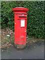
Elizabethan postbox on Gartcraig Road
Postbox No. G33 1038.
See Image] for context.
Image: © JThomas
Taken: 30 Mar 2017
0.14 miles
2
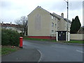
Gartcraig Road
Showing position of Postbox No. G33 1038.
See Image] for postbox.
Image: © JThomas
Taken: 30 Mar 2017
0.14 miles
3
Barlinnie Prison
Once home to Abdel Baset al-Megrahi, convicted for the 1988 Lockerbie bombing which killed 270 people. http://www.geo.ed.ac.uk/scotgaz/features/featurefirst7716.html
Image: © Chris Upson
Taken: 24 Feb 2006
0.15 miles
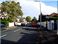
4
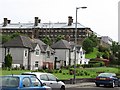
Lethamhill Road
Lethamhill Road is dominated by Barlinnie Prison.
Image: © Richard Webb
Taken: 16 Jun 2011
0.17 miles
5
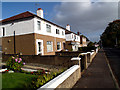
Riddrie Knowes
More typical housing further east on Riddrie Knowes.
Image: © Rosalind Mitchell
Taken: 22 Oct 2015
0.17 miles
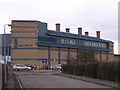
6
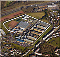
HMP Barlinnie from the air
Scotland's largest prison was built between 1882-97 and holds over one thousand inmates in five halls. It is located in Riddrie by the M8 motorway in the east end of Glasgow.
Image: © Thomas Nugent
Taken: 19 Mar 2018
0.17 miles
8
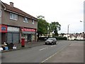
Star Discount Store
Shop on Bellrock Street.
Image: © Richard Webb
Taken: 16 Jun 2011
0.20 miles
9
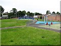
Open space, Lethamhill Road
Small park with a football court and play apparatus, Riddrie.
Image: © Richard Webb
Taken: 16 Jun 2011
0.21 miles
10
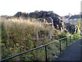
Limestone outcrop
Outcrop of carboniferous limestone between Riddrie Knowes and Gogar Street.
Image: © Rosalind Mitchell
Taken: 22 Oct 2015
0.21 miles