IMAGES TAKEN NEAR TO
Dinart Street, GLASGOW, G33 2BU
Introduction
This page details the photographs taken nearby to Dinart Street, G33 2BU by members of the Geograph project.
The Geograph project started in 2005 with the aim of publishing, organising and preserving representative images for every square kilometre of Great Britain, Ireland and the Isle of Man.

There are currently over 7.5m images from over14,400 individuals and you can help contribute to the project by visiting https://www.geograph.org.uk
Image Map
Images are licensed for reuse under creativecommons.org/licenses/by-sa/2.0
Notes
- Clicking on the map will re-center to the selected point.
- The higher the marker number, the further away the image location is from the centre of the postcode.
Image Listing (22 Images Found)
Images are licensed for reuse under creativecommons.org/licenses/by-sa/2.0
Image
Details
Distance
1
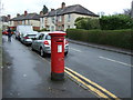
Dinart Street
Showing position of Postbox No. G33 1007.
See Image] for postbox.
Image: © JThomas
Taken: 30 Mar 2017
0.02 miles
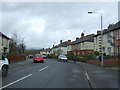
5
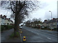
Cumbernauld Road, Riddrie
Looking north on the A80.
Image: © JThomas
Taken: 30 Mar 2017
0.05 miles
6
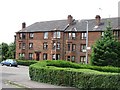
Sandstone tenements, Don Street
The corner of Don Street and Dinart Street
Image: © Richard Webb
Taken: 16 Jun 2011
0.06 miles
8
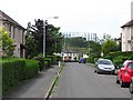
Brora Street
Residential street with a view of Provan Gasworks, across the M8.
Image: © Richard Webb
Taken: 16 Jun 2011
0.06 miles
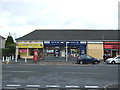
9
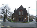
St Enoch?s Hogganfield, Church of Scotland Parish Church
Image: © JThomas
Taken: 30 Mar 2017
0.06 miles
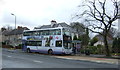
10
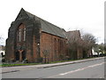
St Enoch's Hogganfield Parish Church
Situated at the corner of Cumbernauld Road and Smithycroft Road.
Image: © G Laird
Taken: 28 Mar 2009
0.07 miles