IMAGES TAKEN NEAR TO
Briarcroft Drive, GLASGOW, G33 1RJ
Introduction
This page details the photographs taken nearby to Briarcroft Drive, G33 1RJ by members of the Geograph project.
The Geograph project started in 2005 with the aim of publishing, organising and preserving representative images for every square kilometre of Great Britain, Ireland and the Isle of Man.

There are currently over 7.5m images from over14,400 individuals and you can help contribute to the project by visiting https://www.geograph.org.uk
Image Map
Images are licensed for reuse under creativecommons.org/licenses/by-sa/2.0
Notes
- Clicking on the map will re-center to the selected point.
- The higher the marker number, the further away the image location is from the centre of the postcode.
Image Listing (19 Images Found)
Images are licensed for reuse under creativecommons.org/licenses/by-sa/2.0
Image
Details
Distance
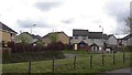
1
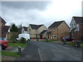
Brookfield Corner, Robroyston
Modern housing development.
Image: © JThomas
Taken: 30 Mar 2017
0.07 miles
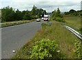
3
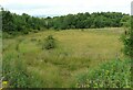
Grassland beside Robroyston Road
Robroyston Road is just behind the trees on the left.
Image: © Richard Sutcliffe
Taken: 16 Jul 2021
0.10 miles
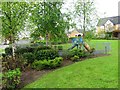
5
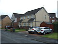
Briarcroft Drive
Newish housing estate in Robroyston.
Image: © Richard Webb
Taken: 9 May 2012
0.14 miles
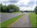
6
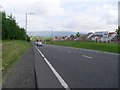
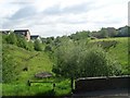
Robroyston Road
Heading north from the Robroyston roundabout.
Image: © Stephen Sweeney
Taken: 3 Jun 2009
0.15 miles
8
Wallacewell Road at Hillhead Road
The end of the dual carriageway Wallacewell Road.
Image: © Stephen Sweeney
Taken: 3 Jun 2009
0.19 miles
9
Robroyston Road
Looking towards the roundabout where it joins the B812, Auchinairn Road.
Image: © Richard Sutcliffe
Taken: 16 Jul 2021
0.19 miles
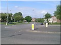
10
Sign on approach to roundabout at Robroyston
Image: © Stephen Sweeney
Taken: 3 Jun 2009
0.21 miles