IMAGES TAKEN NEAR TO
Bargeddie Street, GLASGOW, G33 1NB
Introduction
This page details the photographs taken nearby to Bargeddie Street, G33 1NB by members of the Geograph project.
The Geograph project started in 2005 with the aim of publishing, organising and preserving representative images for every square kilometre of Great Britain, Ireland and the Isle of Man.

There are currently over 7.5m images from over14,400 individuals and you can help contribute to the project by visiting https://www.geograph.org.uk
Image Map
Images are licensed for reuse under creativecommons.org/licenses/by-sa/2.0
Notes
- Clicking on the map will re-center to the selected point.
- The higher the marker number, the further away the image location is from the centre of the postcode.
Image Listing (12 Images Found)
Images are licensed for reuse under creativecommons.org/licenses/by-sa/2.0
Image
Details
Distance
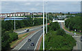
1
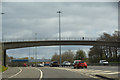
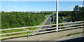
Glasgow City : The M8 Motorway
The M8 seen after joining at junction 13.
Image: © Lewis Clarke
Taken: 25 Apr 2016
0.08 miles
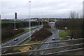
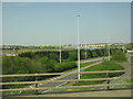
2
Slip roan from the M80 to connect to the M8
Image: © Elliott Simpson
Taken: 3 Sep 2016
0.19 miles
3
The M80 motorway
The southern extreme of the motorway at Provan gas works, viewed from the M8 motorway.
Image: © Thomas Nugent
Taken: 9 Aug 2020
0.21 miles
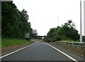
4
The M80 motorway
The southern end of the motorway where it joins the M8, from where this photo was taken. Part of Provan gasworks can be seen on the left.
Image: © Thomas Nugent
Taken: 6 Jan 2013
0.21 miles
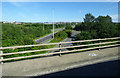
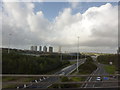
5
The M80 at Provanmill
Looking north from the M8 at J1/13. Beyond is the lowered Provanmill gasholder and housing at Barmulloch.
Image: © M J Richardson
Taken: 11 May 2016
0.21 miles
6
The M80 motorway
The southern end of the motorway, at Provan Gas Works. Viewed from the M8.
Image: © Thomas Nugent
Taken: 14 Jul 2013
0.21 miles
7
Glasgow City : The M8 Sliproad
A sliproad heading down onto the M8 motorway.
Image: © Lewis Clarke
Taken: 25 Apr 2016
0.22 miles
8
M80 at Provanmill
Seen from junction 13 of the M8, going east from Glasgow. High rise flats at Petershill.
Image: © Peter Barr
Taken: 21 Sep 2011
0.22 miles
9
The M80 motorway
The southern extreme of the motorway, viewed from the M8 motorway at Provan gas works.
Image: © Thomas Nugent
Taken: 9 Aug 2020
0.23 miles
10
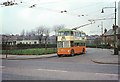
British Trolleybuses - Glasgow
Tay Crescent, Riddrie. This was an intermediate terminus on the long route 106 from Millerston (in the north-east of the city) to Bellahouston in the south-west (south of the Clyde). Glasgow started its conversion of tramways to trolleybuses immediately after the second world war, but only a handful of routes were completed before the decision was made to convert the rest of the system with diesel buses. The trolleybuses outlasted the trams by less than five years. Route 106 was replaced by bus route 38.
This housing estate with its two storey houses marks an intermediate stage between the working class traditional tenements and the high-rise which was already making an impact on the city landscape by the mid-60s.
For a slide show of British Trolleybuses in the late 60s
http://www.geograph.org.uk/search.php?i=1773236&displayclass=slide
Image: © Alan Murray-Rust
Taken: 24 Mar 1966
0.23 miles