IMAGES TAKEN NEAR TO
Glenbuck Avenue, GLASGOW, G33 1DT
Introduction
This page details the photographs taken nearby to Glenbuck Avenue, G33 1DT by members of the Geograph project.
The Geograph project started in 2005 with the aim of publishing, organising and preserving representative images for every square kilometre of Great Britain, Ireland and the Isle of Man.

There are currently over 7.5m images from over14,400 individuals and you can help contribute to the project by visiting https://www.geograph.org.uk
Image Map
Images are licensed for reuse under creativecommons.org/licenses/by-sa/2.0
Notes
- Clicking on the map will re-center to the selected point.
- The higher the marker number, the further away the image location is from the centre of the postcode.
Image Listing (5 Images Found)
Images are licensed for reuse under creativecommons.org/licenses/by-sa/2.0
Image
Details
Distance
1
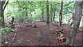
Woodland, Robroyston
A useful bit of singletrack linking Robroyston's new houses and Auchinleck Road. The woods surrounded a hospital, the site of which is now a housing estate.
Image: © Richard Webb
Taken: 9 May 2012
0.17 miles
2
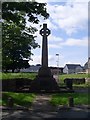
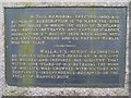
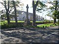
Wallace's Monument, Robroyston
Stands on the site of the house where, in 1305, William Wallace was captured by the English before being taken to his death at the Tower of London.
Image: © Stephen Sweeney
Taken: 3 Jun 2009
0.23 miles
4
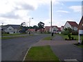
Cortmalaw Close
New housing development in the Wallacefield area north of Robroyston.
Image: © Stephen Sweeney
Taken: 3 Jun 2009
0.24 miles
5
Wallace's Monument
Approaching from the east on Robroyston Road.
Image: © Stephen Sweeney
Taken: 9 Sep 2009
0.25 miles