IMAGES TAKEN NEAR TO
Langdale Street, GLASGOW, G33 1DP
Introduction
This page details the photographs taken nearby to Langdale Street, G33 1DP by members of the Geograph project.
The Geograph project started in 2005 with the aim of publishing, organising and preserving representative images for every square kilometre of Great Britain, Ireland and the Isle of Man.

There are currently over 7.5m images from over14,400 individuals and you can help contribute to the project by visiting https://www.geograph.org.uk
Image Map
Images are licensed for reuse under creativecommons.org/licenses/by-sa/2.0
Notes
- Clicking on the map will re-center to the selected point.
- The higher the marker number, the further away the image location is from the centre of the postcode.
Image Listing (8 Images Found)
Images are licensed for reuse under creativecommons.org/licenses/by-sa/2.0
Image
Details
Distance
1
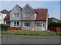
Colourful house on Greenside Street
In Provanmill.
Image: © Stephen Sweeney
Taken: 20 Apr 2009
0.02 miles
3
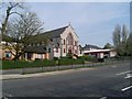
Church on Royston Road
In Provanmill.
Image: © Stephen Sweeney
Taken: 20 Apr 2009
0.10 miles
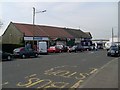
4
Dereliction in Provanmill
At the corner of Provanmill Road and Royston Road.
Image: © Stephen Sweeney
Taken: 20 Apr 2009
0.11 miles
5
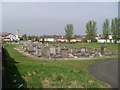
Gravestones in Provanmill Cemetery
What looks like an older section of the cemetery.
Image: © Stephen Sweeney
Taken: 20 Apr 2009
0.19 miles
6
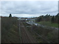
Railway towards Glasgow
Running parallel to the M80 Motorway at this point.
View south west from the bridge on Robroyston Road.
Image: © JThomas
Taken: 30 Mar 2017
0.23 miles
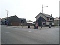
7
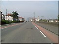
Provanmill Road
Looking west towards the Red Road flats.
Image: © Stephen Sweeney
Taken: 20 Apr 2009
0.23 miles
8
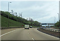
Approaching junction 2 warning sign M80 eastbound
Just passed railway bridge
Image: © John Firth
Taken: 13 May 2012
0.24 miles