IMAGES TAKEN NEAR TO
Grampian Street, GLASGOW, G32 9TB
Introduction
This page details the photographs taken nearby to Grampian Street, G32 9TB by members of the Geograph project.
The Geograph project started in 2005 with the aim of publishing, organising and preserving representative images for every square kilometre of Great Britain, Ireland and the Isle of Man.

There are currently over 7.5m images from over14,400 individuals and you can help contribute to the project by visiting https://www.geograph.org.uk
Image Map
Images are licensed for reuse under creativecommons.org/licenses/by-sa/2.0
Notes
- Clicking on the map will re-center to the selected point.
- The higher the marker number, the further away the image location is from the centre of the postcode.
Image Listing (5 Images Found)
Images are licensed for reuse under creativecommons.org/licenses/by-sa/2.0
Image
Details
Distance
1
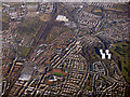
Shettleston from the air
Eastbank Academy is in the left foreground. The four towerblocks are at Sandyhills.
Image: © Thomas Nugent
Taken: 19 Mar 2018
0.19 miles
2

Sandyhills Park, also known as "the Wee Park"
Image: © David McMumm
Taken: 29 Aug 2009
0.23 miles
3
![Killin Street [B765], Shettleston](https://s1.geograph.org.uk/geophotos/03/22/49/3224985_3d0a6c02_120x120.jpg)
Killin Street [B765], Shettleston
At the junction with Gelston Street.
Image: © Christine Johnstone
Taken: 14 Nov 2012
0.23 miles
4
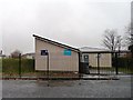
Air Training Corps, Killin Street, Shettleston
Home to the 1089 (7th Glasgow) squadron.
Image: © Christine Johnstone
Taken: 14 Nov 2012
0.24 miles
5

Housing on Sandyhills Road
At Comrie Street.
Image: © Stephen Sweeney
Taken: 30 Apr 2009
0.25 miles