IMAGES TAKEN NEAR TO
London Road, GLASGOW, G32 8XT
Introduction
This page details the photographs taken nearby to London Road, G32 8XT by members of the Geograph project.
The Geograph project started in 2005 with the aim of publishing, organising and preserving representative images for every square kilometre of Great Britain, Ireland and the Isle of Man.

There are currently over 7.5m images from over14,400 individuals and you can help contribute to the project by visiting https://www.geograph.org.uk
Image Map
Images are licensed for reuse under creativecommons.org/licenses/by-sa/2.0
Notes
- Clicking on the map will re-center to the selected point.
- The higher the marker number, the further away the image location is from the centre of the postcode.
Image Listing (14 Images Found)
Images are licensed for reuse under creativecommons.org/licenses/by-sa/2.0
Image
Details
Distance
1
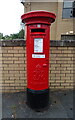
George VI postbox on Kenmuirhill Road
Postbox No. G32 567.
Image: © JThomas
Taken: 13 Sep 2021
0.02 miles
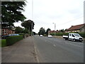
2
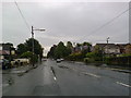
London Road, Glasgow
London Road at Kenmuirhill Road looking West.
Image: © Gordon Dowie
Taken: 20 Apr 2010
0.05 miles
3
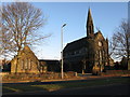
Kenmuir Mount Vernon Church
On London Road, Mount Vernon. http://www.kenmuirchurch.co.uk/
Image: © G Laird
Taken: 30 Jan 2010
0.05 miles
4
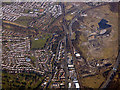
Mount Vernon from the air
The A74 passes under the Argyle Line railway line at Mount Vernon station. The circular building on the left is Mount Vernon Primary School. The Daldowie gravel quarries are on the right, beside the M74 motorway.
Image: © Thomas Nugent
Taken: 19 Mar 2018
0.06 miles

7
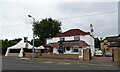
The Woodend, Mount Vernon
On Hamilton Road.
Image: © JThomas
Taken: 13 Sep 2021
0.08 miles
8
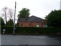
House on Hamilton Road
Viewed from Woodend Road to the east of the property.
Image: © Stephen Sweeney
Taken: 30 Apr 2009
0.12 miles
9
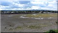
Land awaiting development
A cleared site between what used to be the A721 (Hamilton Road) and the A74(London Road) at Mount Vernon, 1970s maps show this to be an excavated site (quarries or mine workings)
Image: © Richard Webb
Taken: 23 Apr 2012
0.12 miles