IMAGES TAKEN NEAR TO
Maukinfauld Road, GLASGOW, G32 8TT
Introduction
This page details the photographs taken nearby to Maukinfauld Road, G32 8TT by members of the Geograph project.
The Geograph project started in 2005 with the aim of publishing, organising and preserving representative images for every square kilometre of Great Britain, Ireland and the Isle of Man.

There are currently over 7.5m images from over14,400 individuals and you can help contribute to the project by visiting https://www.geograph.org.uk
Image Map
Images are licensed for reuse under creativecommons.org/licenses/by-sa/2.0
Notes
- Clicking on the map will re-center to the selected point.
- The higher the marker number, the further away the image location is from the centre of the postcode.
Image Listing (9 Images Found)
Images are licensed for reuse under creativecommons.org/licenses/by-sa/2.0
Image
Details
Distance
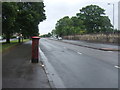
1
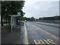
Bus stop and shelter on London Road (A74)
Opposite John Dewar and Sons distillery.
Image: © JThomas
Taken: 29 Jun 2017
0.07 miles
2
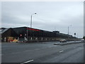
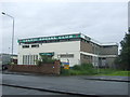
John Dewar and Sons
Scottish distillery and whisky blender on London Road (A74).
Image: © JThomas
Taken: 29 Jun 2017
0.11 miles
4
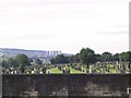
St. Peter's Cemetery
Archdiocese of Glasgow, at Dalbeth.
Image: © Roger May
Taken: 9 Aug 2005
0.18 miles
5
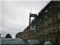
Maukinfauld Road Glasgow
Housing in Maukinfauld Road under repair.
Image: © edward mcmaihin
Taken: 15 May 2011
0.19 miles
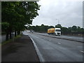
6
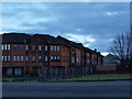
Modern tenements on London Road
These buildings, pictured here in the first light of the day, are on the north side of London Road just across from St Patrick's cemetery.
Image: © Alec MacKinnon
Taken: 30 Mar 2018
0.20 miles
9
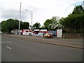
London Road, Braidfauld
Looking south east showing position of Postbox No. G32 209.
See Image] for postbox.
Image: © JThomas
Taken: 29 Jun 2017
0.25 miles