IMAGES TAKEN NEAR TO
Pencaitland Grove, GLASGOW, G32 8RN
Introduction
This page details the photographs taken nearby to Pencaitland Grove, G32 8RN by members of the Geograph project.
The Geograph project started in 2005 with the aim of publishing, organising and preserving representative images for every square kilometre of Great Britain, Ireland and the Isle of Man.

There are currently over 7.5m images from over14,400 individuals and you can help contribute to the project by visiting https://www.geograph.org.uk
Image Map
Images are licensed for reuse under creativecommons.org/licenses/by-sa/2.0
Notes
- Clicking on the map will re-center to the selected point.
- The higher the marker number, the further away the image location is from the centre of the postcode.
Image Listing (20 Images Found)
Images are licensed for reuse under creativecommons.org/licenses/by-sa/2.0
Image
Details
Distance
1
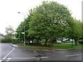
Trees alongside Falside Road
Approaching the junction with Tollcross Road.
Image: © Stephen Sweeney
Taken: 30 Apr 2009
0.10 miles
2
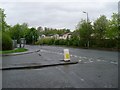
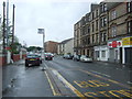
Tollcross Road
At the junction with Falside Road.
Image: © Stephen Sweeney
Taken: 30 Apr 2009
0.11 miles
4

Sandyhills Drive
Housing estate just off Killin Street in Sandyhills.
Image: © Stephen Sweeney
Taken: 30 Apr 2009
0.17 miles
5
Bus stop on Tollcross Road
Looking south east.
Image: © JThomas
Taken: 29 Jun 2017
0.19 miles
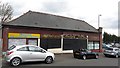
6
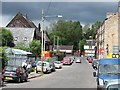
Causewayside Street
Mixed light industry/services and residential area of Tollcross.
Image: © Richard Webb
Taken: 29 Jun 2011
0.20 miles
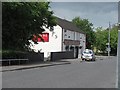
7

Fullarton Park
Home of Vale of Clyde, Glasgow Junior football club.
Image: © Stephen Sweeney
Taken: 30 Apr 2009
0.21 miles
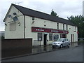
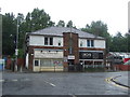
9
Elder's Bar
A bar on Causewayside Street, Fullarton.
Image: © Richard Webb
Taken: 29 Jun 2011
0.22 miles