IMAGES TAKEN NEAR TO
Broomhill Avenue, GLASGOW, G32 8EB
Introduction
This page details the photographs taken nearby to Broomhill Avenue, G32 8EB by members of the Geograph project.
The Geograph project started in 2005 with the aim of publishing, organising and preserving representative images for every square kilometre of Great Britain, Ireland and the Isle of Man.

There are currently over 7.5m images from over14,400 individuals and you can help contribute to the project by visiting https://www.geograph.org.uk
Image Map
Images are licensed for reuse under creativecommons.org/licenses/by-sa/2.0
Notes
- Clicking on the map will re-center to the selected point.
- The higher the marker number, the further away the image location is from the centre of the postcode.
Image Listing (14 Images Found)
Images are licensed for reuse under creativecommons.org/licenses/by-sa/2.0
Image
Details
Distance
1

Carmyle Parish Church
The parish church of the large village in the south-east of Glasgow.
Image: © James Denham
Taken: 16 Nov 2013
0.02 miles
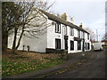
2
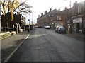
Carmyle shopping
The main street in Carmyle, Glasgow.
Image: © James Denham
Taken: 16 Nov 2013
0.04 miles
3
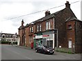
Carmyle Post Office
On Gardenside Avenue.
Image: © Richard Webb
Taken: 29 Jun 2011
0.06 miles
5
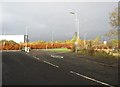
Leaving Carmyle
Junction of the village and the A763 heading to Cambuslang.
Image: © James Denham
Taken: 16 Nov 2013
0.14 miles
6
The Auld Hoose Inn, Carmyle
The pub is closed at the moment but it appears there is some work going on so perhaps?
Image: © James Denham
Taken: 16 Nov 2013
0.17 miles
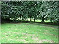
7
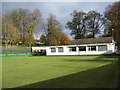
Carmyle Bowling Club
The green and the clubhouse in the small Glasgow suburb.
Image: © James Denham
Taken: 16 Nov 2013
0.18 miles
8
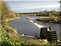
The River Clyde at Carmyle
An atmospheric weir an some old workings. This 'V' weir is said to have powered mills on both sides of the river.
Image: © James Denham
Taken: 16 Nov 2013
0.22 miles
9
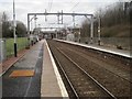
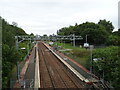
Carmyle railway station, Glasgow
Opened in 1866 by the Rutherglen and Coatbridge Railway, later part of the Caledonian Railway, this station closed in 1964. It was rebuilt and reopened in 1993 as part of the Glasgow to Whifflet line. View west towards Rutherglen and Glasgow following electrification. For a view in the opposite direction some three years earlier, see Image
It had also previously been the junction for the Glasgow Central Railway via Tollcross and Bridgeton Cross, with a further 2 platforms to the right. These are now buried underneath the M74 motorway embankment.
Image: © Nigel Thompson
Taken: 9 Feb 2017
0.23 miles
10
Carmyle Railway Station
On the Whifflet Line.
Image: © JThomas
Taken: 13 Sep 2021
0.23 miles