IMAGES TAKEN NEAR TO
Gardenside Crescent, GLASGOW, G32 8DT
Introduction
This page details the photographs taken nearby to Gardenside Crescent, G32 8DT by members of the Geograph project.
The Geograph project started in 2005 with the aim of publishing, organising and preserving representative images for every square kilometre of Great Britain, Ireland and the Isle of Man.

There are currently over 7.5m images from over14,400 individuals and you can help contribute to the project by visiting https://www.geograph.org.uk
Image Map
Images are licensed for reuse under creativecommons.org/licenses/by-sa/2.0
Notes
- Clicking on the map will re-center to the selected point.
- The higher the marker number, the further away the image location is from the centre of the postcode.
Image Listing (18 Images Found)
Images are licensed for reuse under creativecommons.org/licenses/by-sa/2.0
Image
Details
Distance
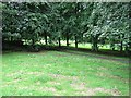
2
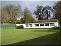
Carmyle Bowling Club
The green and the clubhouse in the small Glasgow suburb.
Image: © James Denham
Taken: 16 Nov 2013
0.12 miles
3
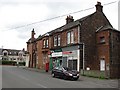
Carmyle Post Office
On Gardenside Avenue.
Image: © Richard Webb
Taken: 29 Jun 2011
0.13 miles
4
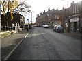
Carmyle shopping
The main street in Carmyle, Glasgow.
Image: © James Denham
Taken: 16 Nov 2013
0.16 miles
5

Carmyle Parish Church
The parish church of the large village in the south-east of Glasgow.
Image: © James Denham
Taken: 16 Nov 2013
0.17 miles
6
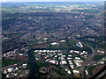
Carmyle and the east end from the air
The River Clyde and the M74 Northern Extension can be seen heading west.
Image: © Thomas Nugent
Taken: 9 Jun 2012
0.17 miles
7
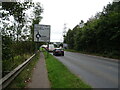
Clydeford Road (A763) approaching roundabout
Heading south towards Cambuslang.
Image: © JThomas
Taken: 13 Sep 2021
0.18 miles
8
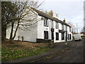
The Auld Hoose Inn, Carmyle
The pub is closed at the moment but it appears there is some work going on so perhaps?
Image: © James Denham
Taken: 16 Nov 2013
0.19 miles
9

River Clyde
Upstream from the Clydeford Road Bridge between Cambuslang and Carmyle. The bridge replaced the Cambuslang Bridge when the roads were realigned. The bridge shakes a lot when lorries cross it.
Image: © Richard Webb
Taken: 29 Jun 2011
0.21 miles
10
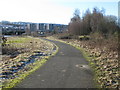
Clyde Walkway nearing Cambuslang
Also part of Route 75 of the National Cycle Network.
Image: © G Laird
Taken: 31 Jan 2010
0.22 miles